By the Cascadia Initiative Expedition Team (CIET)
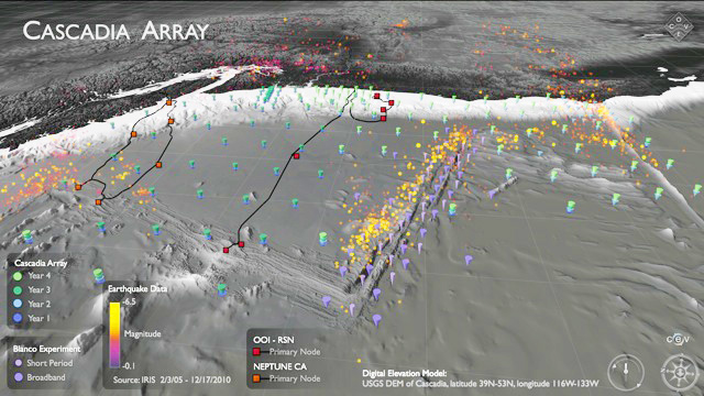
Figure 1. Oblique shaded relief map showing the Cascadia Array.::The four-year deployments plan of the OBS array, cabled networks associated with NEPTUNE Canada and OOI, earthquake distributions, oceanic spreading centers, and transform faults are all shown.
The Cascadia Initiative (CI) is an onshore/offshore seismic and geodetic experiment that takes advantage of an amphibious array to study questions ranging from megathrust earthquakes to volcanic arc structure to the formation, deformation and hydration of the Juan de Fuca and Gorda plates. This diverse set of objectives are all components of understanding the overall subduction zone system and require an array that provides high quality data that crosses the shoreline and encompasses relevant plate boundaries. An article in the previous GeoPRISMS Newsletter (Spring 2011, issue No. 26) described CI scientific objectives, the outcome of an open community workshop held in October 2010 to develop deployment plans for the offshore component of the experiment, and formation of the Cascadia Initiative Expedition Team (CIET). This article provides an update of CIET activities including the first year of CI OBS deployments (summer 2011) and related Education and Outreach (E&O) efforts.
Over its planned 4-year data acquisition period, the offshore portion of the Cascadia Initiative will involve the deployment and recovery of ~280 OBSs at ~160 different sites and a total of about 14 cruises. Each OBS deployment site requires careful evaluation to ensure that the notional deployment plans developed at the 2010 CI workshop take into consideration local bathymetry, trawling hazards and the presence of fragile ecosystems. The CIET incorporates this information into a detailed deployment plan that includes a prioritized deployment schedule. It is anticipated that the adjustments to most deployment sites will be minor (e.g., small changes in drop coordinates to avoid geological hazards or take advantage of preexisting multibeam bathymetry). However, practical considerations may require some larger changes to the notional plans developed at the 2010 CI workshop in which case the CIET has developed a procedure for revisions, as described on the CIET web site. Scientific oversight is required at sea to ensure that operation decisions driven by instrument failures, bad weather or other factors are guided by the scientific objectives of the experiment. A detailed cruise report will be produced for each cruise to fully document the experiment.
The CIET has been actively discussing and planning the 2011 deployments for several months. Since we are geographically distributed and our schedules are often conflicting we use a variety of communication tools. These include regular emails, a CIET web site that provides wiki capabilities, and bi-weekly conference calls with minutes and action items posted to the CIET site. The CIET website is currently used by the group for communication, discussion and limited data exchange. Much of the website content is viewable by the community. Looking toward the future, the CIET site will also be used for education and outreach, communication with the scientific community, and development and delivery of metadata pertaining to OBS deployments and recoveries (e.g., cruise reports). The CIET will hold its first face-to-face meeting this fall in Seattle on September 13 and 14.
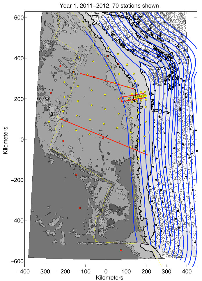
Figure 2: Year 1 Deployment Plan.::Red circles denote the reference array. Yellow circles denote the Regional Array. Yellow squares denote the Focused Array. Yellow diamonds denote the densified coverage of the forearc enabled by requesting 10 additional instruments from the OBSIP pool. Black circles denote on land broadband seismometers. Red squares denote the NEPTUNE Canada seismometers. Blue lines denote slap depth contours (every 10 km). The 1000 m bathymetry contour is shown in bold. See 2010 CI Workshop Report for further descriptions.
2011 FIELD SEASON
In accord with the deployment plan developed at the CI Workshop, the CIET proposed to NSF to deploy 70 OBSs during the 2011 field season according to the Year 1 plan (Fig 1). All of the OBS deployments will be done from the R/V Wecoma. Given the limited deck space on this ship, 3 cruises will be required to deploy all 70 OBS. The cruise schedule and chief scientists for 2011 operations are as follows:
- Leg 1, July 23 – August 2, 2011. Chief Scientists: Maya Tolstoy (LDEO), Anne Trehu (OSU)
- Leg 2, October 15-29, 2011. Chief Scientists: Robert Dziak (OSU), Del Bohnenstiehl (NCSU)
- Leg 3, October 30 – November 12, 2011. Chief Scientists: John Collins (WHOI), Emilie Hooft (UO)
CI Leg 1 – W1107A: The first OBS deployment cruise for the Cascadia Initiative took place between July 23rd and August 2nd 2011 aboard the Research Vessel Wecoma. The cruise deployed 15 of the newly designed LDEO-OBSIP Trawl Resistant Mounted OBSs or TRM-OBSs; the original goal was to deploy 20 TRM-OBSs, however, 5 were not fully built. These instruments are designed to provide a shield around the seismometer that should both reduce current noise and provide some protection from the bottom trawl fishing that occurs along the Cascadia margin. The instruments were therefore targeted for deployment at shallow sites (<1000 m) where trawling and currents are most likely to be an issue. The TRM-OBSs contain a Trillium compact seismometer as well as a Paros Instruments Absolute Pressure Gauge (APG), which should be useful in reducing long period noise and in measuring seafloor deformation. The TRM-OBSs will record continuously at 125 samples/sec until they are recovered in early summer 2012 using either an attached pop-up buoy system (instruments < 200 m water depth) or a Remotely Operated Vehicle (ROV).
The TRM-OBSs were largely used to fill the sites of the northern focused array that were < 1000 m depth because of the advantage of having a tight array of APGs. The CIET and the Amphibious Array Steering Committee (AASC) provided a prioritized list of sites prior to the cruise to enable the co-chief scientists to adapt the deployment pattern as necessary while at sea. Individual site locations were adjusted based on feedback from the chair of the Oregon Fisherman’s Cable Committee (OFCC), and different iterations of site locations were identified with the letters B, C and D appended to the site name and number. It is important for both the instruments and the safety of the fishing community and their equipment that regularly fished sites be avoided.
One site was inadvertently deployed at a heavily fished site, and attempts to recover it using the attached pop-up buoy failed. The instrument ended up upside down, which was a serious hazard to the fishing community. This instrument was recovered on August 14th by John Delaney and Deborah Kelley (UW), who generously took time out of their Visions11 cruise to pick up the TRM-OBS using ROV Ropos aboard the R/V Thompson. A video of the recovery can be seen online.
Two community college students were able to join the cruise as part of a summer enrichment program designed by Dean Livelybrooks (Univ. of Oregon) to introduce community college students to science. A PhD graduate student and an undergraduate IRIS summer intern also participated. Having a full complement of watchstanders and 2 co-PIs enabled us to operate research around the clock. While the OBS team slept, 4 & 12 kHz surveys were conducted to image bubbles in the water column from cold seeps in the region.
This cruise was the first full deployment of this new OBS design, and as such, much was learned. You can read a detailed account of the cruise activities in the cruise report which can be found at the CIET website. We are grateful to the Captain and Crew of the R/V Wecoma and the science party, who all worked extremely hard to make the cruise as successful as it was.
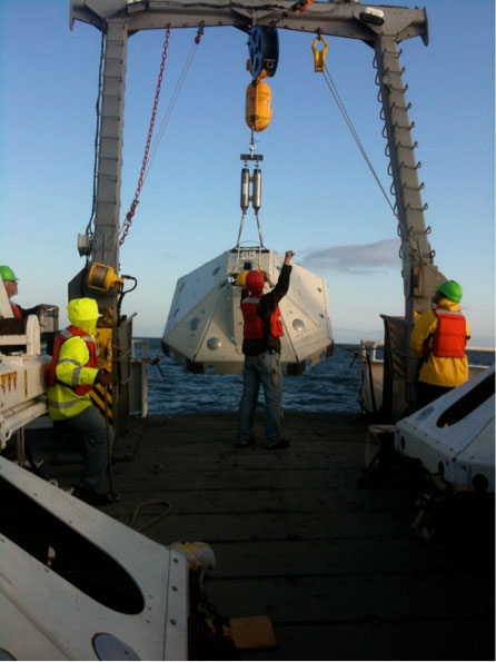
Figure 3. An LDEO-TRM OBS being deployed aboard the R/V Wecoma in July 2011.::The white octagonal frame is designed to sink a few inches into the sediment and shield the seismometer from current noise and trawl fishing.
CI Leg 2: The second CI leg will take place from October 15-29, 2011 aboard the R/V Wecoma, leaving from and returning to Newport, OR. This expedition will deploy 25 OBSs, 15 from SIO and 10 from LDEO. The fifteen SIO OBSs will also be installed in trawl-resistant enclosures and are equipped with Differential Pressure Gauges (DPGs); these instruments are deployable at depths extending from the shelf down to 6,000 m. The remaining ten LDEO instruments are not in trawl resistant enclosures and so must be deployed below 1,000 m; they do carry APGs.
CI Leg 3: The third CI leg will take place from October 30 – November 12, 2011 aboard the R/V Wecoma, leaving from and returning to Newport, OR. This expedition will deploy 25 OBSs, 15 from WHOI and 10 from the OBSIP pool. All these OBSs are not trawl resistant and will be deployed at depths deeper than 1000 m; they carry DPGs.
CI EDUCATION AND OUTREACH
The Cascadia Initiative Education and Outreach (E&O) program is developing two opportunities during its first year, led by Dean Livelybrooks (UO):
1. The ‘CC@sea’ project supports community college (‘CC’) student participation in OBS deployment, retrieval and pre-cruise and follow-up outreach activities in CCs, high schools and the community. CC@sea> leverages another NSF (STEP) program, Undergraduate Catalytic Outreach and Research Experiences (UCORE) that has built strong ties with six Oregon community colleges. Two community college (‘CC’) students participated in the 23-July to 2-August OBS deployment cruise of the R/V Wecoma. The Fellows stood watch, helped with instrument deployment and made movies of all aspects of sea-going research. Dean Livelybrooks also participated in this first sea-going leg to initiate and supervise these activities. The goal of the CC@sea> program is to attract students from diverse, non-traditional backgrounds to a four-year degree in physical sciences and that these students transfer their experiences to the community and their peers. CC@sea> personnel made a very entertaining and informative video suitable for other community college and high school students during the first deployment leg, which will be shown in science classes at participating UCORE campuses and elsewhere.
2. A fall planning, teacher professional development workshop for a seismometers @ schools (S@S) program, where teachers and students, with assistance, install, monitor, and interpret seismograms and characterize shaking at school sites to advocate for seismic retrofit upgrades in older schools in the Pacific NW.
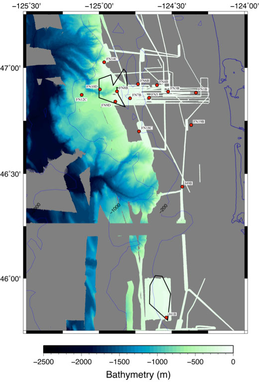
Figure 4. Final deployment locations for W1107A cruise
CIET Membership:
Doug Toomey (Team Leader, University of Oregon), Richard Allen (University of California, Berkeley), John Collins (Woods Hole Oceanographic Institution), Bob Dziak (OSU/NOAA, Newport, OR) Emilie Hooft (University of Oregon), Dean Livelybrooks (University of Oregon) Jeff McGuire (Woods Hole Oceanographic Institution), Susan Schwartz (University of California, Santa Cruz), Maya Tolstoy (Lamont Doherty Earth Observatory), Anne Trehu (Oregon State University), William Wilcock (University of Washington)
GeoPRISMS Newsletter, Issue No. 27, Fall 2011. Retrieved from http://geoprisms.nineplanetsllc.com