1Michigan State University, 2Lamont Doherty Earth Observatory
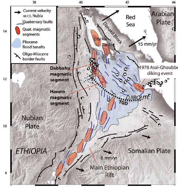
Figure 1. Map of the Afar rift region showing major tectonic and magmatic features from Ebinger et al., 2008.
Conference Overview
The Magmatic Rifting and Active Volcanism (MRAV) Conference took place in Addis Ababa, Ethiopia January 10-13, 2012, convened by members of the Afar Rift Consortium, an international team investigating active magmatism and deformation in the Afar region. Over 200 people from around the world attended. The conference participants primarily presented the results of work on ongoing rifting processes in Afar, but work was also presented that addressed other portions of the East African Rift, comparable rift settings elsewhere, rifting processes in general, and the hazards and resources associated with the East African Rift.
The scientific program outlined the current state of knowledge in the East African rift and placed recent discoveries within the broader context of rift-related research globally. Central to the meeting was the presentation of results from thematic, multi-collaborator, international programs (e.g. Afar Consortium, RiftLink, Actions Marges), individual research groups, and industrial partners. The rich detail and modern datasets presented at the meeting highlight the importance of the existing infrastructure of international research in East Africa, which should be leveraged by GeoPRISMS to effectively focus resources in the extensive East African Rift System primary site.
Scientific Advances Related to GeoPRISMS Goals in East Africa
What follows is a brief summary of scientific results reported at the MRAV conference. A complete volume of abstracts and the program can be found at http://www.see.leeds.ac.uk/afar/new-afar/conference/conference.html. We present these results in the context of the questions outlined in the GeoPRISMS science Implementation Plan for the East Africa Rift System (EARS).
How is strain accommodated and partitioned throughout the lithosphere, and what are the controls on strain localization and migration?
A significant focus of the conference was the 2005 Dabbahu rifting event, which was dominated by a series of 14 dike intrusions and 4 eruptions with an estimated 2.5 km3 of magma intruded since September 2005. The initial Dabbahu diking events affected a large portion (60 km) of the magmatic segment, while subsequent activity was more localized. Several lines of evidence (including InSAR and seismicity) indicate that diking preceded and drove seismicity in the Dabbahu events. Importantly, the seismic moment and the associated slip along faults accounts for only 10% of the geodetic moment, indicating that most deformation in this rifting event was taken up aseismically, through dike injection or other igneous intrusion. Many aspects of this rifting resemble the 1974-89 rifting event at Krafla, in Iceland.
Additional recent tectonic activity reported on at the conference included the 2010 Gulf of Aden seismic swarm, which occurred along three segments of the rift at depths of less than 10 km. The 1989 Dobi earthquake swarm in central Afar appears to have followed a “bookshelf faulting” model, with slip occurring on at least 14 different faults during the earthquake sequence. The Asal rift was imaged with RADARSAT from 1997-2008; this time series showed 2-3 m of opening, accompanied by subsidence in the rift itself and uplift on the flanks with some component of shear.
What factors control the distribution and ponding of magmas and volatiles, and how are they related to extensional fault systems bounding the rift?The Dabbahu event was dominantly a diking phenomenon, with magma playing a key role in crustal deformation. Similar to other portions of the rift, fractional crystallization processes and magmatic plumbing systems differ between axial and off-axis magmas. Resistivity surveys, surface velocity models, and receiver functions in the Dabbahu area all suggest that some 3000 km3 of magma remains in the crust, possibly stored in elongated magma chambers parallel to the rift axis, and that these may erupt on ~40 ka cycles. At upper mantle and lower crustal depths, the resistivity structure of active and inactive segments of the Afar rift are similar. The most significant heterogeneity exists at mid-crustal depths and is related to the presence or absence of melt.
Very high-resolution seismicity obtained through deployment of seismometer arrays helps detail the relationship between magmatic activity and faulting. While normal faulting occurs during the diking process, regions where magmatism has occurred are less seismically active. More broadly in the region, rift basalts show expected age progression with the youngest basalts at the center of the rift, and pointing to a spreading rate of 12 ± 1 mm/yr. However, less clear is off-axis magmatism, which shows no simple age progressive trend.
How does the mechanical heterogeneity of continental lithosphere influence rift initiation, morphology, and evolution?Many presentations addressed aspects of the rift beyond the Dabbahu event. Comparing the recent, well-studied and well-constrained rifting event in Afar with the longer geologic record highlights that these processes change over time. Primarily, the asymmetry of the Afar rift suggests that the locus of rifting has migrated eastward. The orientation of different fault sets in the Asal-Danakil rift indicate two different directions of tension between 1.35 Ma and 0.3 Ma. This could be due to magmatic loading and flexure of the crust in addition to extension. Paleomagnetic data suggest minor block rotation (~7°) in Afar. The marginal grabens on the western edge of Afar are enigmatic: still seismically active, on top of the steepest gradient of crustal thickness. They are likely developed over crustal flexure, and the variability from north to south is controlled by migration of a wave of erosion. Farther south, thermochronology from the Albertine section of the rift show a complex, multi-stage cooling history and differential uplift within mountain blocks.
Several geophysical results suggest that structures at the surface mimic and reflect structures at depth in the lithosphere. Crustal anisotropy (fast direction) and the geoelectric strike both match the orientation of surface structures, with a transition zone in Afar. Both also increase in the magmatic segments of the rift: anisotropy is sensitive to strain fabrics, and MT to presence of melt. Shear-wave splitting directions in the mantle are different below mid-ocean ridges and the East African Rift. Below the Main Ethiopian Rift, they are parallel to rift axis; below the EPR, they are perpendicular to the rift axis. At slower-spreading ridges (mid-Atlantic and Gakkel), they are more variable. Gravity profiles across Dabbahu suggest a Moho depth of 19 or 23 km, and that faults at the surface may continue at depth.
How does the presence or absence of an upper-mantle plume influence extension?
At a wider scale, discussions focused on the lithosphere-asthenosphere boundary and how the thermo-chemical state of the East African upper mantle impacted the rifting process in East Africa. The nature of the lithosphere-asthenosphere boundary differs on the rift flanks in comparison to the central part of the rift. Beneath the flanks, velocities decrease with depth, suggesting melt pockets at the lithosphere-asthenosphere boundary, whereas velocities increase with depth beneath the main rift. These properties mean that at ~70 km depth, the rift in Afar resembles the East Pacific Rise. These observations are consistent with observations that at 50-150 km depth, the lowest seismic velocities follow the ridge structure. However, at 300 km depth, there is a very broad anomaly that lacks structure and extends down to the transition zone. Elevated mantle potential temperatures are detected in Afar and throughout the East African rift, supporting seismic evidence of a deep upwelling. Despite these elevated temperatures, the magnitude of the observed seismic anomalies cannot be explained solely by a thermal means and requires a chemical component within the upwelling.
How does rift topography, on either the continental- or basin-scale, influence regional climate, and what are the associated feedback processes?
Rifting affects climate through the construction of topography, which can have a significant effect on the local distribution of precipitation. Results of modeling experiments suggest that both tectonic events (the development of high topography associated with rifting) and orbital forcing (variability in insolation) are likely to have affected climate in eastern Africa over the last 20 million years. The East African Rift is also an excellent location to explore the mesoscale affects of orography, due to the presence of multiple lakes. Lakes generate their own weather, and interact with prevailing winds and local topographic features. There are coring efforts underway in Lake Malawi to test these effects. Rift lake sediments preserve unique records of climate and tectonics, including key time intervals in hominid evolution.
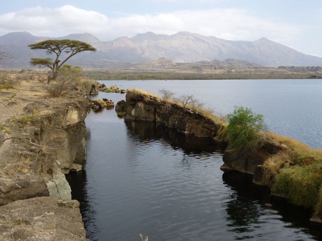
Figure 2. A fissure on the edge of Lake Besaka. Fantale volcano is in the background; it last erupted 170,000 years ago.
Broader Impacts
Hazards
Volcanic hazard risks associated with Ethiopian volcanoes are unexpectedly high, largely due to the uncertainties associated with individual volcanic centers. In particular, the geologic record is temporally limited. Of concern is that InSAR observations have shown that there are far more volcanoes that are currently deforming than have erupted historically, suggesting significant potential for future eruptions. To more broadly assess volcanic hazard potential, the NERC-funded ‘Global Volcano Model’, in cooperation with 12 international partners, seeks to better characterize potentially hazardous volcanoes.
Remote volcanic hazard monitoring through SO2 emissions, InSAR, thermal imaging, and infrasound, provide means to monitor volcanoes in difficult to access areas. Eruptions in remote regions may not have an immediate hazard impact due to sparse habitation, however the Nabro event in Eritrea was determined to have been the largest SO2 producer since 1991. These remote sensing techniques therefore have further application for global SO2 models with obvious implications for climate change studies.
Resources
The economic potential of East Africa is substantial; energy, commodity and tourism resources are clear growth areas. Epithermal gold deposits in Afar that are associated with geologically modern hydrothermal systems linked to rift magmatism are targets of active exploration. The gold potential of these systems is enhanced by the relatively low salinity magmatic environment in the rift. The resources being devoted to this epithermal play speak to the resource potential of currently active rifts (i.e. we do not have to wait for them to fill with sediments and develop oil).
There is extensive oil exploration in Lake Albert region in Uganda, and many boreholes have been drilled. Little production is occurring at this time, due to transport constraints, although estimates of the resources are substantial (~1000 million barrels). Oil exploration has also focused on the Lake Turkana region, where very detailed gravity, magnetic surveys and mapping have been completed.
Significant challenges remain in the electrification of East Africa. Only 15% of East Africans have access to electricity with an average consumption of 68 KwH/yr (compared with ~2500 KwH/yr per person globally). With current production, every East African could light a 60W bulb 3 hours/day. Energy production needs to expand 33 fold. So far, only ~1% of the geothermal potential of the Ethiopian Rift has been exploited. And while geothermal energy is a key area of exploration, there are inherent problems with power generation and cost scaling – small facilities are more costly to operate. There is also a drive to construct more dams for hydropower in Ethiopia, but the selection of dams is complicated by seismic and volcanic activity, which may be episodic.
One particularly interesting presentation addressed geotourism as a growing industry that should be examined in more detail, including prioritizing the generation of digestible information and graphics for visitor centers.
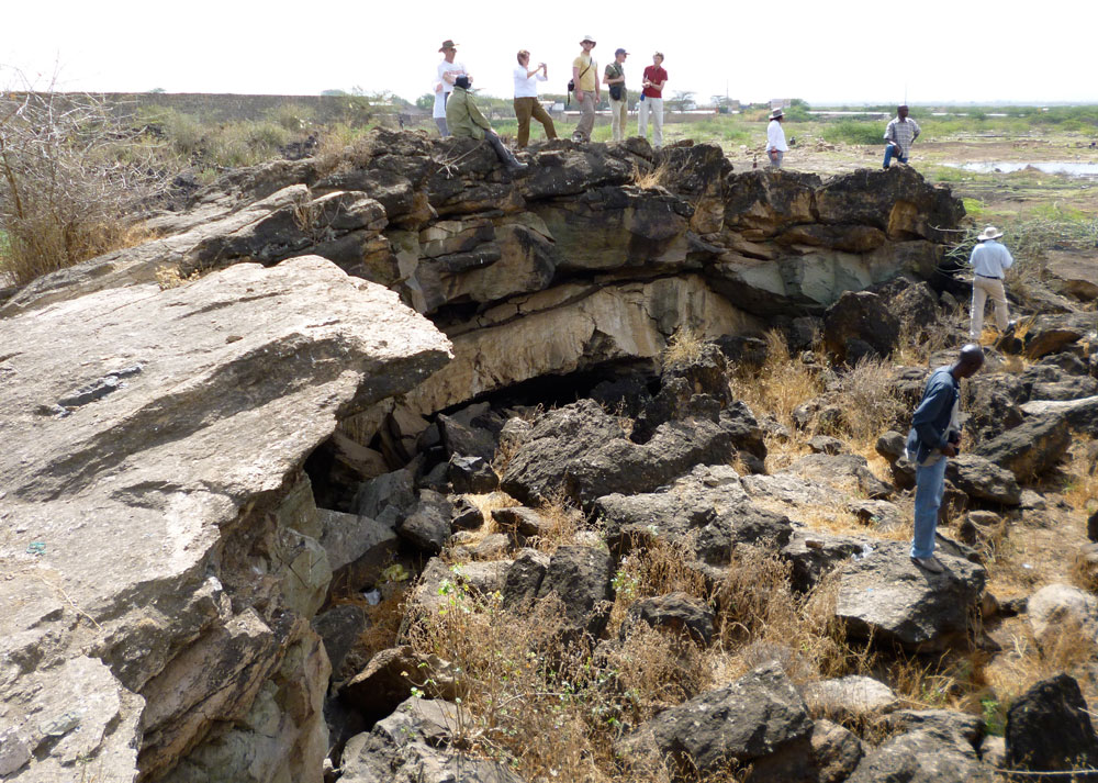
Figure 3. Field trip participants examine ‘blister cave’ in a welded tuff in the southern Afar.
Future Opportunities and Challenges for GeoPRISMS
Attendees expressed strong interest in continuing research in the Afar region, as well as other parts of the East African Rift. Several projects are continuing or planned, and there are multiple opportunities for GeoPRISMS. Close collaborations with African scientists, particularly, will be essential to the success of GeoPRISMS work in the EAR, and many scientists from Ethiopia and elsewhere who attended the meeting expressed enthusiasm for such interactions.
The conference was opened by the Ethiopian Minister for Mines, who emphasized her desire to engage international scientists and the need to translate the scientific knowledge gained through research into economically useful information. The logistical, cultural, and administrative challenges of working in East Africa require and benefit from close collaboration with scientists from the host countries. Many of the participants from Africa were directly involved in the energy, commodity, or tourism industries, or other efforts that closely link to the scientific research being undertaken in the region. Another opportunity for GeoPRISMS scientists is to build successful cooperative efforts by linking the fundamental research to applications in energy, resource development, and hazards mitigation that can yield tangible benefits to the host country.
The conference was closed by the Dean of Research at Addis Ababa University, who articulated the need for a better understanding of the rift and its consequences for hazards and announced a new 5-year, $10 M Ethiopian birr (over $500,000 USD) initiative focused on hazards. Representatives from energy companies (including geothermal and hydrocarbon) and mining companies also attended the meeting and expressed interest in collaborating with international academic teams to better understand the tectonics and their consequences for resources. In January 2013, the 24th Colloquium of African Geology will be held in Addis Ababa, with sessions dedicated to the East African Rift, providing an additional opportunity to focus GeoPRISMS’ efforts.
Numerous graduate students from around the world were present at the meeting, as well as several undergraduates from Addis Ababa University. The opportunities to build research capacity in Africa by involving graduate and undergraduate students from the host countries in research are tremendous, and should be a part of any GeoPRISMS effort.
Ultimately, GeoPRISMS must work closely with East African scientists and develop a strategy that complements and capitalizes on existing initiatives. The opportunities for meaningful collaborations are significant.
Reference informationGeoPRISMS Newsletter, Issue No. 28, Spring 2012. Retrieved from http://geoprisms.nineplanetsllc.com