Chris Goldfinger, Oregon State University
As part of the 2009 Stimulus or ARRA (American Recovery and Reinvestment Act) spending, NSF’s Earth Sciences (EAR) and Ocean Sciences (OCE) divisions each received $5M in facility-related investment. The funds were targeted toward the creation of an Amphibious Array Facility to support EarthScope and MARGINS (now GeoPRISMS) science objectives. The initial emphasis and deployment site was onshore/offshore studies of the Cascadia margin, with an expectation that the facility would later move to other locations.
At the October 2010 CEIT OBS workshop held in Portland OR, a number or practical issues were raised in conjunction with this ambitious OBS deployment. One of these was the issue of good bathymetric data needed for good siting and safety of the instruments along the Cascadia margin. In addition, Cascadia is also now the site of the main components of the Ocean Observing Initiative (OOI) and Neptune Canada, the world’s premier cabled observatory systems, and these will be in operation collecting real-time data from a wide spectrum of sensors for decades to come. Cascadia has also now been chosen and a Focus Site for the NSF GeoPRISMS program, which will focus attention on Cascadia earthquake tectonics for the next decade.
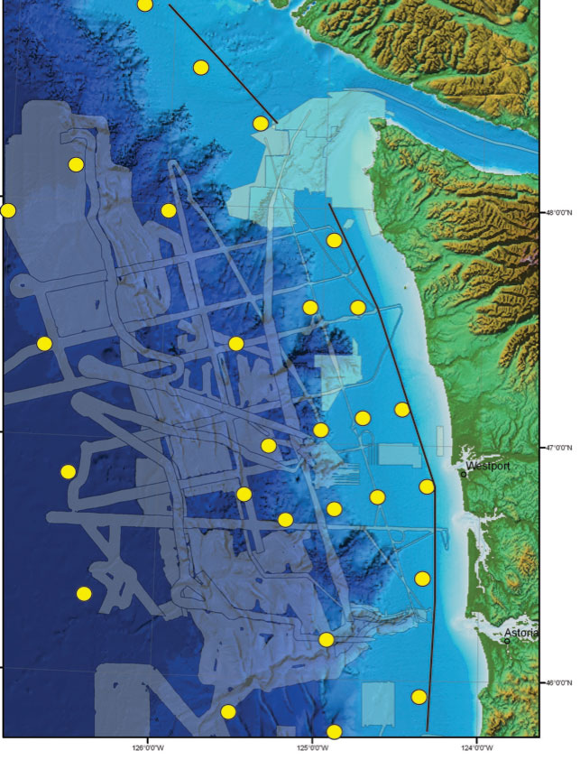
Figure 1. “Before” Bathymetric coverage of the Washington-Vancouver Island margin. Translucent overlay shows existing multibeam coverage from most known cruises mostly collected by OSU and restricted until recently. Remaining areas are only covered by sparse NOS soundings. Yellow dots are approximate OBS deployment locations for year one. Some of these were re-located to better sites in terms of trawl protection and topography after the 2011 cruise data were processed.
Bathymetric data for the OBS deployments
Good bathymetric data are essential for siting OBS station locations and ensuring the best chance of the instruments settling to the bottom in relatively smooth flat areas with a good chance of good recording fidelity. Equally important is to deploy instruments in areas where the topographic, structural, and hydrologic context is reasonably well understood, so that a maximum number of instruments will be recovered from each deployment. Some of the CI deployed instruments will be located on the abyssal plain of the Juan de Fuca plate, and are relatively safe from local geohazards. However, this initiative specifically addresses the Cascadia subduction boundary, and thus most of the instrument deployments are on the continental margin of this very dynamic plate boundary (Figure 1). Because many of the deployments span a number of active canyon systems and seismically active areas, good bathymetric data are also required to prevent a number of instruments from being swept into channels and canyons and lost or damaged during the deployment.
Current state of Cascadia bathymetric coverage
In the NE pacific region, the Cascadia margin and Cascadia basin has spotty coverage of modern multibeam data. 1980’s vintage EEZ survey data cover Oregon and Northern California from ≈600 m to the abyssal plain out to 1260W. This includes a major survey of the Gorda Plate done during an extended sea trial of the then new AGOR Ronald H. Brown. Much of the ridge system at The Gorda, Juan de Fuca and Explorer ridges and Blanco, Mendocino and the Nootka faults have multibeam data collected over the years during NSF and NOAA sponsored work. The EEZ data were collected in the 1980’s with the original 90 degree Seabeam Classic, now quite antiquated, but adequate for regional context. There are also very large gaps in even these data. The EEZ data collected in the 1980s off Washington was first “classified” by the Navy due to their submarine activity there, and then subsequently “lost” while in storage. Consequently, comprehensive coverage of the Washington margin has not been available. Through the 90’s and early 2000’s, OSU collected data on the WA margin in support of paleoseismic and other cruises, and there were also several cruises of the German vessel Sonne. These data were collected in mission specific areas, and with a variety of systems, and therefore not ideal for regional coverage. Releases of these data were for a time also restricted by the Navy, but since 2008 the data are no longer restricted, nor is collection of new data by academic and Government agencies. These older data were collected with now antiquated systems, including the original Krupp Atlas Hydrosweep and SeaBeam classic and SeaBeam 2000 systems. Shallow data, less than ≈600 m, are even more sparse. Some of the shallow banks in Oregon have been mapped with high resolution systems, and several other NOAA, NSF, MMS and state supported projects have mapped small portions of the shelf, but an estimated 75% of waters shallower than 600m remain unmapped.
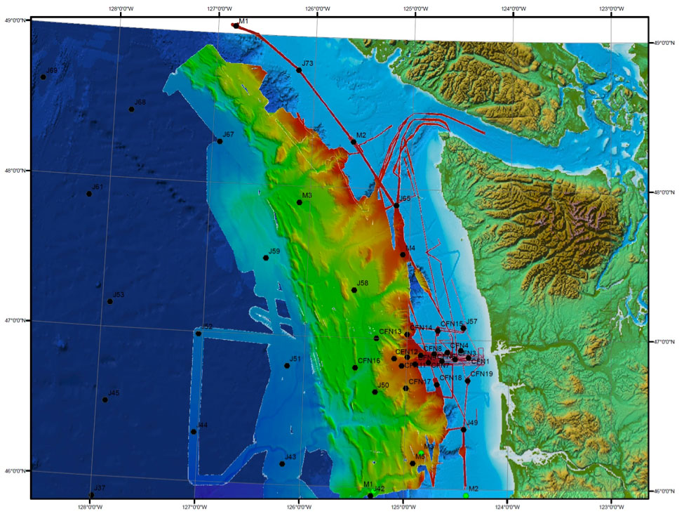
Figure 2. “After” Bathymetric coverage of the Washington-Vancouver Island margin following the June 2011 CEIT cruise with modified OBS locations. New and old data have been assembled in CARIS bathymetric database software.
The need for new bathymetric data
At a minimum, small patches of bathymetric data are desirable for site location of Cascadia margin OBS sites, where even the location of major canyon systems is only approximately known (Washington and Vancouver Island). Minimal patch size should be at least a few km2 in order to ensure safe and effective deployments. A better approach however would be to survey contiguous larger areas that serve to aid in deployments, but also to establish the structural context of the deployments and of the Cascadia margin, which was the approach supported for this project.
Beyond the CIET OBS deployment, this project took the opportunity to, for the first time, obtain a nearly complete image of the Cascadia Subduction Zone that will make significant steps toward filling gaps in our knowledge of the regional tectonics of the Cascadia margin. The project is supportive of the goals of the CIET OBS array, the OOI and GeoPRISMS objectives, and also directly addresses the issue of regional earthquake hazards. The ideal vessel for this purpose was the R/V Thomas Thompson, with its newly upgraded Kongsberg EM-302 multibeam system, with the best resolution for the ≈1000-2500 m target depth range for much of the survey. This vessel, working at survey speeds can also collect concurrent 3.5 kHz Chirp sub-bottom data during the survey work, which is also useful for deployment assessment and many other purposes.
In planning the cruise, we prioritized the most hazardous sites on the margin, and also prioritized completion of margin coverage that is useful for OOI, GeoPRISMS, and regional context. Most mid-plate sites are relatively near existing coverage, but will be surveyed on future cruises if possible before deployment (Figure 1).
The priority survey area on the Washington margin is shown in Figure 1 with existing multibeam coverage along with approximate OBS site locations. Final site choices have and will take advantage of less hazardous sites than shown in Figure 1, as well as trawl closures and the existing Olympic Coast Marine Sanctuary to avoid natural and anthropogenic hazards.
Figure 2 shows the “after” picture of the Washington-Vancouver Island margin. Older bathymetric data have been combined with new data in CARIS in this image. Ongoing work will attempt to reconcile the several generations of sonars used, tide, velocity and other corrections as well as to edit and improve the older data where possible to produce a final surface integrated with existing soundings where multibeam data are still lacking. This will also be done for the Oregon-Northern California parts of the margin where less extensive new data were also collected to fill smaller gaps. A final compilation of the Cascadia margin will be made available to the community when complete in 2012
GeoPRISMS Newsletter, Issue No. 27, Fall 2011. Retrieved from http://geoprisms.nineplanetsllc.com