Kerry Key (Scripps Institution of Oceanography) and Ninfa Bennington (University Wisconsin-Madison)
It all sounded so easy when we were writing the proposal. Sure, we can deploy 54 seafloor magnetotelluric (MT) instruments around a remote Aleutian island, no problem, we have done lots of marine MT surveys before. Add on an array of onshore magnetotelluric and passive broadband seismic stations covering the flanks and caldera of a volcano that erupted without almost no warning back in 2008? Sure, that won’t be too hard either since we will have a helicopter transporting the field teams and science equipment, and we can base our camp at a remote cattle ranch used by previous field teams studying Okmok volcano. So we worked up a budget, wrote the proposal text and submitted it to the July 2014 target date for proposal submissions to the National Science Foundation’s GeoPRISMS program.
Fast forward to early January 2015 when we received an email from Bil Haq, then one of the two NSF Program Managers for GeoPRISMS, stating “Your proposal did well in the competition for GeoPRISMS funds and I plan to fund it at this time”.
Yes!!!!! Woohoo!!!!!! Seriously, this was good news.
Then comes the word that the field work will start in mid-June. We were supposed to get everything in place for two short cruises and three weeks of onshore field work in just a few months. Time to get moving!
The Logistics
We started a seemingly endless chain of emails and conference calls to work out the logistics for the onshore field work. We would be working out of a field camp at Bering Pacific Ranch on the abandoned WWII military base Fort Glenn, located on the eastern flank of Umnak island. Our tasks were to get a helicopter, about fifty barrels of helicopter fuel, seismometers, magnetotelluric instruments, cooking supplies and food for about 160 person-days delivered by the start of field operations around June 20th. The tiny city of Dutch Harbor, conveniently located about 100 km away on neighboring Unalaska Island, is the country’s largest fishing port by volume, so we planned to ship our stuff from the lower 48 states up to Dutch Harbor, where it would be consolidated and then shipped to Fort Glenn. Easy right?
Amazingly, this plan actually worked out. Once all the geophysical equipment, batteries, helicopter fuel, non-perishable food and cooking supplies arrived in Dutch Harbor, it was loaded onto the Island Packer, a small landing craft, and then ferried on a 60-km journey from Unalaska Island to a makeshift dock at the beach near Fort Glenn. Then two ranch hands transported it 5 km up to the field camp at the ranch.
By comparison, preparing for the marine part of the project was relatively straightforward since the Scripps lab does this routinely and all we had to do was get the marine MT equipment to the ship. By coincidence, our deployment cruise was scheduled on the RV Thompson, which happened to be passing through San Diego on its way north, so we lucked out and loaded the marine MT gear onboard for a free ride up to the Aleutians.
June 16-17, 2015 | Making it to Dutch Harbor
Dutch Harbor was also the port of departure for the marine MT deployment cruise so we flew into Anchorage and then boarded connecting flights to Dutch Harbor. While anywhere else in the US this would likely be an easy connection, flights to the Aleutian islands are unpredictable due to frequent low hanging clouds and fog. When the planes take off in Anchorage, they don’t know how the weather will be in Dutch Harbor so they load enough fuel on board to make the return trip if visibility is so bad they can’t see the Dutch Harbor runway. This was indeed the case for several of our connecting flights, and so it took a few attempts spread out over a few days for everyone to finally make it to Dutch Harbor. At the local grocery store Safeway, which was unexpectedly well stocked with a cornucopia of fresh produce, we gave the manager a lengthy shopping list of fresh produce, dairy, meat and seafood and he promised it would be delivered to the airport on the morning of June 22, where it would be loaded onto the charter flights taking us west to Fort Glenn.
June 18-21, 2015 | Deployment Cruise
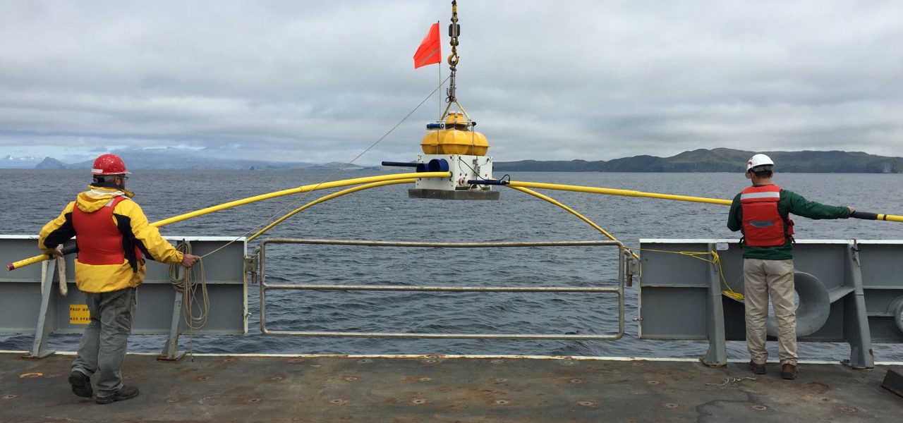
We pushed off the dock around mid-day on the 18th and by 01:00 on the 19th the ship arrived at the first station, located on the northern end of the survey profile in the Bering Sea. By 10:00, we had already deployed seventeen seafloor MT receivers. The sky was filled with low hanging clouds so we couldn’t see Umnak Island, but the lack of view was made up for by the lack of wind and almost no swell – perfect conditions for the maiden marine flight of our consumer-grade drone, allowing us to capture some 4K high definition videos of ship and the science team deploying MT receivers. While waiting in port during the previous days, we had done a lot of prep work, including putting batteries in the 54 data loggers for the MT receivers, synchronizing their crystal oscillator clocks with GPS time and programming them to startup around the time we predicted they would be on the seafloor. So now for each receiver deployment, all we had to do is mount the magnetic field induction coil sensors on the receiver frame along with the two long electric dipole arms, attach the external electronic compass, plug in all the sensor cables, secure the concrete anchor strap, test the acoustic release system, test the stray-line buoy’s radio and finally attach the bright orange flag to the frame. There is a well-developed procedure for all these steps and checklist to make sure nothing is skipped, so it all goes like clockwork thanks to the careful efforts of the students, postdocs and technicians working either the noon-to-midnight or midnight-to-noon shifts (ship-time is not cheap so the vessel works 24 hours a day).
The clouds partially lifted in the late afternoon of the 19th as we entered Umnak Pass, a narrow channel that separates Umnak Island on the west from Unalaska Island on the east. The MT deployment carried on like clockwork and by the 20th we were making way into the Pacific Ocean, which was starting to kick up with strong winds and some moderate swell. We finished the last MT deployment about twelve hours ahead of schedule so we decided to use the extra time to collect high resolution multibeam bathymetry on the forearc slope before heading back to Dutch Harbor. Our journey back to port went about the northern shore of Unalaska, and with luck the clouds lifted partially to give some nice views of Mount Makushin volcano. As usual, soon after the ship tied up most of the crew and science party headed to the local bar to re-equilibrate after a few days on a dry ship.
June 21-July 8, 2015 | Onshore field work
The next phase of the project started with flights from Dutch Harbor to Fort Glenn that transported the science party, two ranch hands, and the perishable food that Safeway had just delivered. From the gravel landing strip (left over from WWII) at Fort Glenn, a ranch hand drove the science party and food up to the camp house where we would stay. The camp house was basically three trailer units arranged in a u-shape with an aluminum roof overtop and a giant garage door on the open side of the U. One unit was a cooking trailer with full kitchen and dinner area. Another was a bunk house and the third was a bathroom, shower and laundry facility. While we weren’t going to exactly be roughing it, nobody had stayed here in several years and everything was covered in mold and black volcanic dust, and the window sills were graveyards of giant fly corpses. We spent much of the first day cleaning up the place, stocking the kitchen and setting up workbenches for the geophysical equipment in the enclosed space in the middle of the three trailers. Sometime during the first day the helicopter arrived and everything was coming together for us to begin operations the next day.
Our seven-person science team would helicopter into and around Okmok volcano. Half of the crew carried out an onshore magnetotelluric survey collected in an array using a combination of long-period and wide-band MT systems, with nineteen stations within the caldera and ten stations outside. The remainder of our field team installed thirteen temporary broadband seismometers both in and around the volcano. The temporary seismic array recorded seismic data until its retrieval in summer 2016. In tandem with the Alaska Volcano Observatory’s twelve permanent seismic stations, there were twelve seismic instruments within/at the rim of the caldera and fourteen seismic instruments outside the caldera.
Both the seismic and MT teams operated in parallel so the helicopter went back and forth ferrying the teams around. That meant we always had to be prepared to be left overnight (or longer) at field stations if the fog came in and the helicopter couldn’t return to pick us up (luckily this never happened, despite a few close calls). We also had to be prepared for being chased by one or more of the ~7000 feral cattle that roam the outer flanks of the caldera. We quickly developed a protocol where after dropping off a team, the helicopter would fly in a 1-km circle around the station chasing away any nearby cattle. Despite this, there was an occasion where the seismic team had to make haste into a ravine to get away from an angry bull. While the MT systems only needed to record data for a few days and thus were all recovered by the end of the first field season, the broadband seismic systems were going to record seismic waves for the next year and would be picked up during the second field season.
July 9-14, 2015 | Recovery cruise
For the marine MT recovery cruise, we were on a different ship, the newly built RV Sikuliaq. Recovering the marine MT receivers meant driving up to them in the ship, sending an acoustic command that tells the instrument to let go of its anchor and then waiting for the instrument to rise to the sea surface. Once on the surface, the instrument’s stray line buoy radios the ship with its GPS position. The ship then drives up to the floating instrument from the downwind side and once its alongside the ship, we toss a grapnel around the stray line and use that to attach the instrument to the ship’s remotely operated crane, which then lifts it aboard. We successfully recovered all instruments except one that was deployed in a dicey location in Umnak Pass where there were strong currents that we suspect carried the instrument away after it released its anchor.
July 29 – Aug 6, 2016 | Recovery of seismic instruments
In summer 2016, we returned to Umnak Island to recover the seismic instruments. This time our operations were based on marine vessel Maritime Maid. Operations continued in a similar fashion to the previous field season with helicopter providing the team’s transportation to and from Okmok. However, this year there was an added level of excitement as take-offs and landings were carried out on the ship’s small helipad. Due to unusually cloudless blue skies and warm temperatures, we demobilized all thirteen seismic sites in a matter of several days. Amazingly, and quite happily, we found that the majority of stations were still up and running when returning to the sites for demobilization. After a rapid and successful field season, we departed from the wonderful Maritime Maid crew and made our way back home. ■


“Report from the Field” was designed to inform the community of real-time, exciting GeoPRISMS -related research. Through this report, the authors expose the excitement, trials, and opportunities to conduct fieldwork, as well as the challenges they may have experienced by deploying research activities in unique geological settings. If you would like to contribute to this series and share your experience on the field, please contact the GeoPRISMS Office at info@geoprisms.nineplanetsllc.com. This opportunity is open to anyone engaged in GeoPRISMS research, from senior researchers to undergraduate students.
We hope to hear from you!