Erin DiMaggio (Arizona State University)
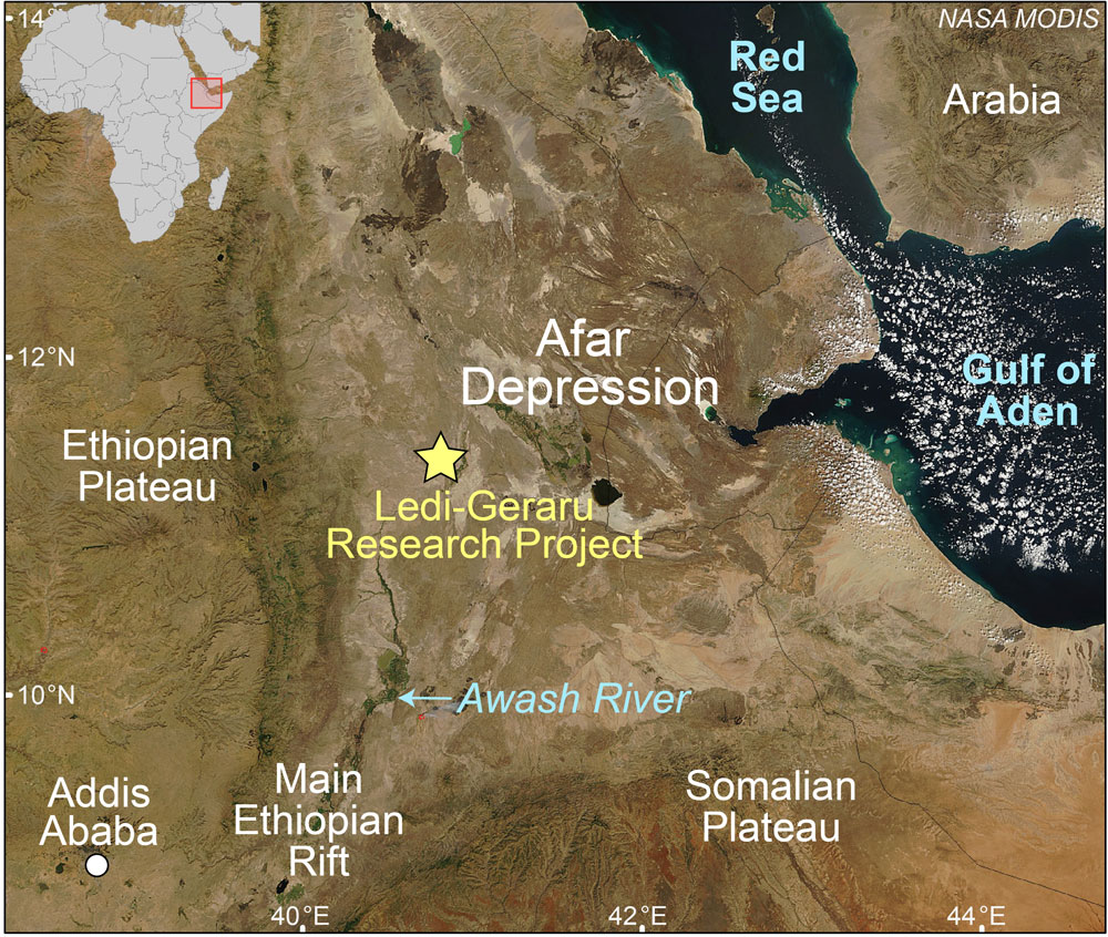
Figure 1. NASA MODIS imagery of the Afar Depression highlighting the location of the Ledi-Geraru Research Project.
The 2013 Ledi-Geraru Research Project field season brought together geologists, paleontologists, and archaeologists from multiple universities to study the environmental context of human evolution in the Afar Depression, Ethiopia. Our field area is located in the southern Afar Depression, near the famous early hominin sites of Hadar and Dikika. This season we focused our efforts on the eastern portion of Ledi-Geraru (ELG) because of its fossiliferous sediments, presence of stone tools, and extensive outcrops. We also targeted this location because the time period represented by the sediments at ELG is scarcely represented in the sedimentological record in Ethiopia and in East Africa in general. As a result, we lack knowledge about important events during this time period including major changes in faunal (animal) populations, and the beginning of stone tool manufacture. Furthermore, the faulting history of the Afar Depression since the late Pliocene (<3.0 Ma) is captured in the structure and geomorphology of the region, all nicely exposed along tributaries of the Awash River. Below I organized some of my field notes to provide a short preview into the daily life and culture at the Ledi-Geraru Camp. Enjoy!
“I am dirty, smelly, and have obviously not showered in three days of field work, but I had a chocolate donut for breakfast. This camp is great!” I mentioned this to my advisor, Ramón Arrowsmith one morning after finishing a freshly made donut and gearing up for another day in the field. It’s true! Aside from the constant barrage of dust that coats anything left out for more than 30 seconds, and afternoon temperatures that make me want to join the Afar hiding under the Land Cruiser for a quick shady nap, I have to admit that our camp life is pretty plush. Our cooks are pros at setting up a fully functional and clean kitchen, including a bread baking station, a deep fryer for our nightly fill of fried potatoes, and a food storage system that somehow defies the laws of spoilage and bug infestation. I can’t even manage to keep a bottle of contact solution in my tent without somehow attracting a line of ants! We are served dinners that include a range of pasta dishes, fried eggplant, and my personal favorite, goat kebobs and tomato salad, all of which are served with soup, fried potatoes, fresh bread, and veggies.
All Under One Tent (1/21/2013)
Today, Brian wanted to better understand the geologic context for some of the fossils found in a particular region earlier in the day. Brian Villmoare (George Washington University) and Dominique Garello, a geology graduate student (Arizona State University), are sporting stylish red/blue 3D glasses because I do most of my geology mapping on anaglyphs created from aerial photographs. I also use high resolution (0.5 meter) satellite imagery for mapping faults or the extent of a volcanic ash deposit, which I later check in the field. It was not until I arrived in the field and completely immersed myself in multiple research worlds that I genuinely understood interdisciplinary research. Geologists, archeologists, and paleontologists all actively collected data within one shared field area and organized, planned, and analyzed results under one central work tent. For example, our geologic mapping helps to determine which archeology sites the archaeologists will focus their efforts on, and faulting patterns that we map one day may direct where paleontologists survey or collect fossils the next day. We are continually communicating our results and changing our plan for the following day based on what we have learned.
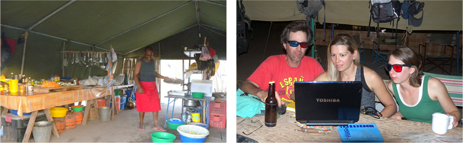
Figure 2. (left) Cook Getachew Senbeto is preparing a great dinner for 40 in our well-organized cook tent. Figure 3. (right) Brian (left), Dominique (right), and I (center) look over the days mapping using anaglyphs (hence, the 3D glasses) to investigate the geology of a fossiliferous area.
The Wild Life (1/22/2013)
This morning we were greeted by a large group of ostriches and gazelle hanging out by the road. There is nothing wilder than an early morning race to the field against a half dozen ostriches! We are also fortunate to see baboons, warthogs, and occasionally a hyena. Later in the day, Dominique and I were taking measurements of faults along a steep cliff outcrop on the banks of the Mille River. Our Afar friend, Ali Yasin, and our representative from the National Museum of Ethiopia, Tesfaye (ARCCH), informed us not to proceed further along the water. We were confused and thought it might be due to that fact we were on loose slopes. We were wrong. Ali had been watching a crocodile slowly approach where we were working. Needless to say, the strike and dip measurement I was after will have to wait for another day!
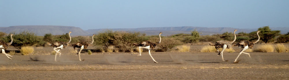
Figure 4. Land Cruiser vs. ostriches – a morning race to our field site.
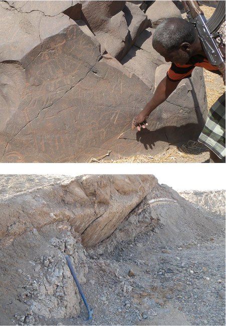
Figure 5. (top) Omar Abdullah showing us stone carvings in basalt boulders. Figure 6. (bottom) Tephra deposits (white and yellow layers) faulted by a beautifully exposed normal fault.
Ancient Rock Art (1/26/2013)
The Afar are proud of their heritage and were very excited to take us on a trip to show us a place near the Awash River where ancient people had created rock art along the sides of one of the basalt hills. In this photo, Omar Abdullah is pointing out a particularly beautiful etched rock with numerous animals including gazelle, camels, pigs, and monkeys! It was relaxing to take a day away from work and play tourist in this beautiful land guided by our Afar friends who were proud to share their land and its history with us.
Geology at ELG (1/27/2013)
The lack of vegetation at ELG, and in the Afar in general, is a blessing and a curse. A blessing because, well, I’m a geologist and there is no shortage of exposed rock! The only hindrance to acquiring a fault plane measurement or measuring and describing a 30 meter stratigraphy section is the sometimes thick cover of eroded sediment – all remedied by good shovel and geology pick. The curse is trying to find a suitable location for lunch, when “Me’e silalo” (good shade in the Afar language) is hard to come by mid-day, often taking the shape of a few feet of shade provided by the Land Cruiser. Today after lunch we found this beautifully exposed fault that slices through two volcanic ash deposits. There is no shortage of faults in the ELG thanks to its proximity to the Afar Triple Junction. In fact, sometimes it is hard to find a complete stratigraphy section to measure that is not interrupted by a fault! Luckily, there are also abundant volcanic ash deposits (or tephras) interbedded in the sediments (see white layers in the photo). Tephras are extremely valuable to the project because they serve as marker beds across the landscape, and some contain crystals that can be dated using 40Ar/39Ar methods, or fresh glass shards that we can use to ‘fingerprint’ the tephra for possible correlation to other areas within ELG or Afar.
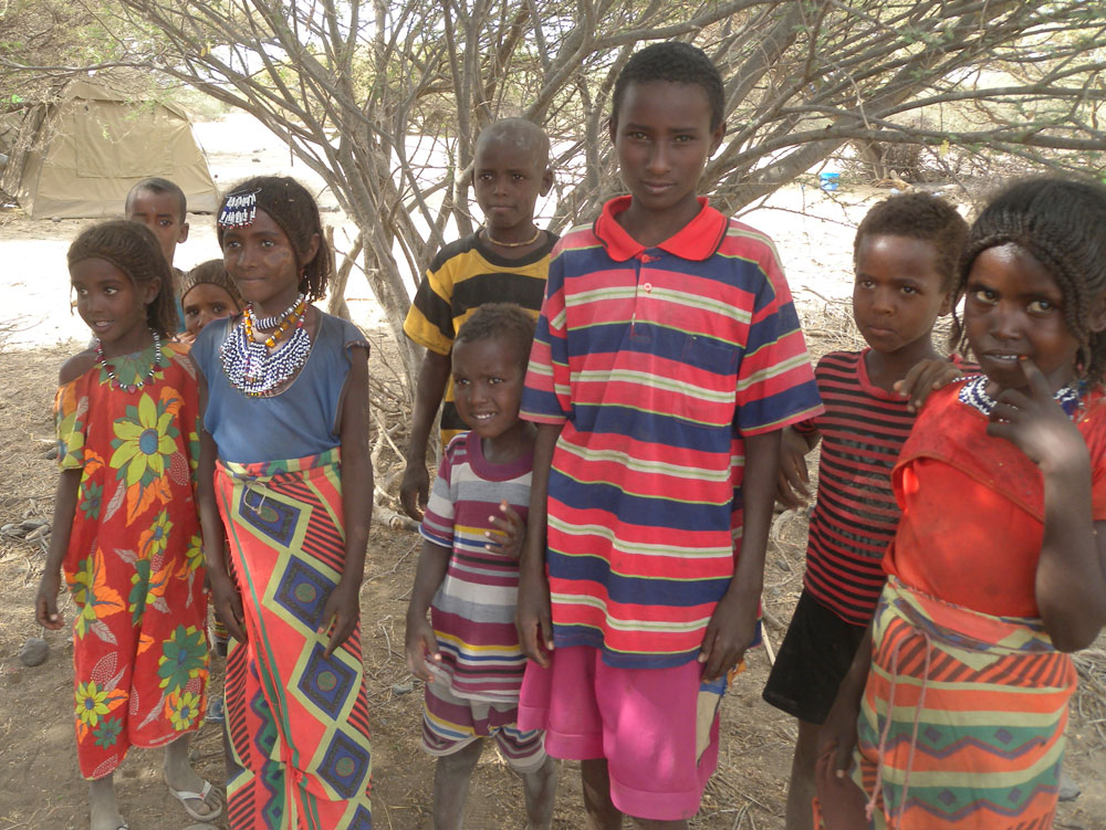
Figure 7. Local Afar children.
Afar Kids (2/1/2013)
The Afar children living and working around our camp site (most Afar children have shepherd responsibilities) love to see what we are up to. Hiding behind trees at a set distance, the kids are curious but shy and quickly warm up when approached. Today we brought out our cameras and had some fun with them taking photos. I realized during my first field season in the Afar a few years back that the Afar kids didn’t seem to smile when I took their photo. Why? Well, simply, we teach kids to smile for the camera from the time they are born, and it becomes second nature. The Afar kids had huge grins on their faces after we took their photo, when they see themselves and their friends on the digital screen. They point at themselves and their friends and giggle, giggle, giggle!
The Fossil Hunt (2/2/2012)
Today the geologists all headed out with paleontologists Kaye Reed, Brian Villmoare (right), graduate student John Rowan (left), and the best Afar fossil hunters to survey and collect fossils (left photo). I learned quite a bit from them including that some fossils are more important than others. What do I mean by that? Because of their size, elephant fossils are commonly found throughout ELG. But collecting elephant fossils is laborious (they are huge!) and are not a very diagnostic species (in contrast to, say, pig fossils). While a few elephant fossils were collected (mostly teeth), elephant and hippopotamus fossil abundance is only noted so that it can be included in later descriptions the region’s paleoecology. In this photo, John and Kaye are holding small yellow ruggedized computers called Nomads. The Nomads are used to store and catalog information (GPS coordinates, element, genus, etc.) about each fossil to a centralized digital database.
Location, Location, Location (2/3/2013)
One of my tasks this season was to complete a gazetteer of Afar place names within the eastern Ledi-Geraru (ELG), including the most ‘correct’ Afar to English spelling and the meaning of the place name. Last night I spent an entire evening with our kind Afar Regional State Representative, Mohammed Hameddin, who did an excellent job of aiding in my not-so-easy quest. Hands down, my favorite place name (and story) is a location in the southern part of ELG, referred to as Dabali Isi. Mohammed spelled out the name for me, while our two best Afar geographers, Ali Yasin and Subudo Baro, explained the meaning of the place name to Mohammed. I knew this was going to be an amusing story because all three men had a smirk on their face during the exchange. Mohammed smiled, stood up and said, “The Afar are telling me that Dabali Isi is named after a woman who was passing through that area. She was very, very beautiful and had…” Mohammed stopped speaking and proceeded to caress his sides and top of his rear end. I was brought to laughter (Mohammed is a very funny man!) and awkwardly had to try and guess the meaning of his gestures. “Does it mean rear end?” Nope. “Sides?” Nope. “Shape?” Yes. As the story goes, Dabali Isi was a very beautiful woman passing through that particular area who had a very, very, memorable womanly form. The Beyoncé of the Afar Depression!
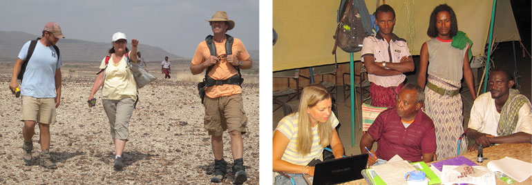
Figure 8. (left) John, Kaye, and Brian (left to right) head out for an exciting day of fossil collecting. Figure 9. (right) Mohammed Ahameddin (sitting, center), Kadar Mohammed, Mohammed Ibrahim, and Ali Yasin (left to right) spell and explain the meaning of local place names for our project gazetteer.
“Lucy Dinga”, a.k.a. Archaeology (2/1/2013)
The Afar people have played an integral role in the work that is conducted in the Afar, some as fossil hunters, others as guides and geology field assistants. Many of the same men return year after year to help in our project, and know well the history that surrounds the search for early humans and stone tools in the outcrops along the Awash that began in the 1970’s. In the Afar language “Dinga” means rock, and almost all of the Afar in the Mille and Elowa region know about the famous discovery of Lucy at Hadar in 1974. As a result the Afar refer to stone tools as “Lucy Dingas”. Today, Dominique and I wanted to see the process of a site excavation and so we spent the afternoon with the archaeologists learning about excavation techniques. We also learned about how to identify “Lucy Dingas” among a wealth of stream fractured cobbles that blanket surfaces across the Ledi-Geraru. In the photo above, from left to right, archaeologists, Will Archer, Yonatan Sahle, and David Braun (U. of Cape Town), prepare for excavation of a site in the Ledi-Geraru. The site is located on the slope on the right, while the total station is located across such that each point is visible and can be accurately measured.
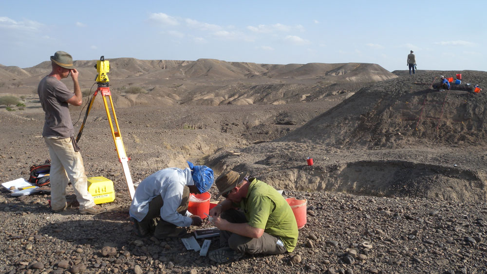
Figure 10. Archaeologists prepare for excavation of a site in the Ledi-Geraru
Overall, we had a very successful field season – we collected new fossils and artifacts, geologic observations, and hundreds of pounds rocks to be analyzed! We hope that this brief glimpse into life at camp, the culture of the Afar people, and the work conducted by Ledi-Geraru researchers opened a door to the process and excitement of conducting field work in Ethiopia.
“Report from the Field” was designed to inform the community of real-time, exciting GeoPRISMS -related research. Through this report, the authors expose the excitement, trials, and opportunities to conduct fieldwork, as well as the challenges they may have experienced by deploying research activities in unique geological settings. If you would like to contribute to this series and share your experience on the field, please contact the GeoPRISMS Office at info@geoprisms.nineplanetsllc.com. This opportunity is open to anyone engaged in GeoPRISMS research, from senior researchers to undergraduate students.
We hope to hear from you!
GeoPRISMS Newsletter, Issue No. 30, Spring 2013. Retrieved from http://geoprisms.nineplanetsllc.com