Taryn Lopez, GeoPRISMS Posdoctoral Fellow (University of Alaska Fairbanks)
Fluid movement in the subsurface of active volcanoes is frequently thought to produce abundant seismicity, but the actual type of fluid, including magma, volcanic gases, or hydrothermal waters, cannot yet be constrained from seismic data. Knowledge of the type of fluids in the subsurface can be determined through chemical and isotopic analysis of volcanic gases. In this project, we aim to combine high temporal resolution measurements of volcanic gas composition and seismicity to help constrain the type of fluid associated with these unique seismic signatures. A two-week field campaign was conducted between July 10 – 24, 2013 at three persistently degassing and seismically active volcanoes within the Katmai Volcanic Cluster (KVC), Alaska, to address this problem. The aims of this work were to collect samples of volcanic fluids for chemical and isotopic analyses and to install campaign instruments to measure gas composition, seismicity, and SO2 flux at high temporal resolution at Mount Martin, Mount Mageik and Trident Volcano.
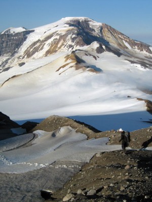
Another day on the field. Francesco Capecchiacci, (from National Reseach Council, Italy) hikes along Mount Martin’s crater rim. Mount Mageik can be seen in the background. The photo was taken in July 2013 by Taryn Lopez during a two-week field campaign conducted in the Katmai Volcanic Cluster in Alaska.
Part 1:
Volcanic gas and seismic instrument installation
July 10, 2013 – After months of planning, the field campaign for my NSF GeoPRISMS postdoctoral fellowship project was about to get underway. Things were off to a reasonably smooth start with both my field partners Bo Galle (Chalmers University Sweden) and Francesco Cappechiacci (National Research Council, Italy) having arrived safely to Alaska and our team en route to King Salmon, Alaska, the closest town to the KVC. We were met in King Salmon by my Alaska Volcano Observatory (AVO) colleagues Dane Ketner and Max Kaufman, who would be conducting maintenance on the AVO Katmai seismic network and assisting with the instrument installations that were critical to my project. After making some last-minute purchases at the local store, my team headed to the hangar of Egli Air Haul, the local company that has provided helicopter and fixed wing service to AVO for fieldwork in Katmai for over 20 years. Our plan was for Francesco, Bo and I, along with our 600+ lbs. of instruments, food, and field gear to get transported to the famous Valley of Ten Thousand Smokes (VTTS), the site of the largest volcanic eruption of the 20th century, the 1912 Katmai-Novarupta eruption. We would set up our base camp at the USGS Research station on Baked Mountain. Dane and Max would be staying in King Salmon for the next six nights and would fly in each day with Sam Egli, our helicopter pilot. Due to weight restrictions my team would be shuttled to the VTTS on a fixed-wing airplane in two shifts and would then have to hike our gear two horizontal miles and 400+ vertical feet from our landing spot to our base camp. We decided that Francesco and I would go in the first shift and start shuttling our most critical assets to camp. The trip to the VTTS was beautiful and we were lucky to have fantastically clear skies allowing for impressive aerial views. Francesco and I began the first of three slow slogs to camp, while our pilot returned for Bo. By 11:00 PM (or approximately 7 hours after departing King Salmon) we had finally transported ourselves and all our gear to camp. We were exhausted, but happy to be there, and had arrived just in time for a beautiful sunset!
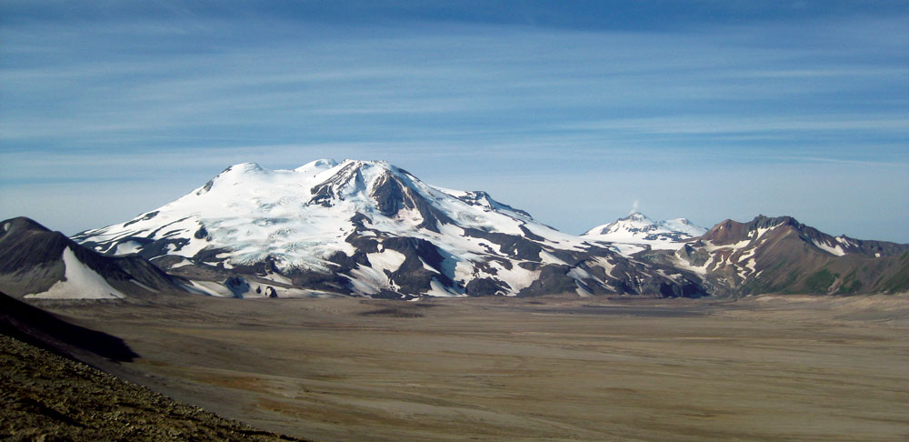
Figure 1. View of Mount Mageik (center) and Mount Martin (right, with plume) as seen from Baked Mountain on 11 July 2013. Photo credit T. Lopez
July 11, 2013 – We awoke to beautiful clear skies, low winds and open-summits at both Martin and Mageik (Fig. 1). Favorable weather conditions like this are atypical of the Alaska Peninsula and we were feeling optimistic that we would complete our field objectives. It was our first of seven days of helicopter support (shared with AVO) during which time we aimed to complete the following tasks: (1) Install MultiGas instruments for measuring volcanic plume composition (CO2, SO2, H2S, and H2O) and broadband seismometers on the summits of Mount Martin, Mount Mageik, and Trident’s southeast fumarole field; (2) Install scanning NOVAC instruments for measuring continuous SO2 flux downwind from Mount Martin and Mount Mageik; and (3) Directly sample the fumarolic emissions from Mount Mageik, Mount Martin and Trident Volcano. Additionally, our USGS colleagues also needed to service several seismic stations. Our plan was ambitious but if the weather cooperated it would be achievable.
At 8:00 AM I made my morning check-in call to Dane, who reported that the weather was also clear in King Salmon and he hoped that they would be flying soon. While much of the first day was spent shuttling batteries, instruments, and station enclosures from King Salmon to the Baked Mountain Camp, by 7 PM that evening, Dane and I finally arrived on the summit of our first target, Mount Mageik. With help from Sam, our pilot, we managed to get much of the hardware for our co-located seismic and MultiGas station installed by 9 PM.
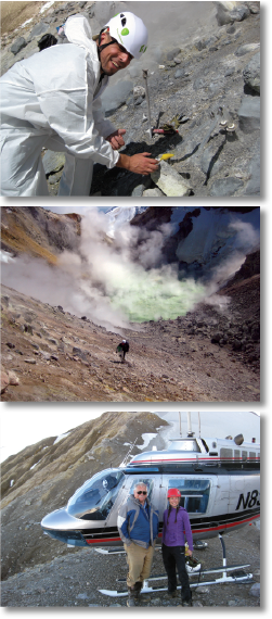
From top to bottom: Figure 2. (a) Francesco Capecchiacci samples volcanic gases in the crater of Mount Mageik. (b) Francesco Capecchiacci hikes up from the crater of Mount Mageik. (c) Sam Egli and Taryn Lopez on the crater rim of Mount Martin. Photos credit T. Lopez
July 12, 2013 – The next morning, we awoke to similarly glorious conditions! By noon, Sam had dropped Dane and I off at Mageik’s summit to complete our work. While we continued working on the installation, Sam shuttled Max and Bo to the proposed site for installing the Mageik NOVAC station and then brought Francesco to join us at the summit. Francesco and I were hoping to hike down into the crater of Mount Mageik to sample the fumarolic gases and crater lake water. Working on active volcanoes can be a hazardous job, especially for gas geochemists who often need to spend time within active craters to get the most useful samples. Mageik’s steep-sided crater walls and abundant gas emissions which could eliminate visibility with the slightest wind-change, induced what I hoped was just the right amount of caution to allow us to be successful and stay safe. The wind was blowing the plume to the south, which meant that we had good visibility and access to the fumaroles on the north crater wall. We scrambled fairly easily down the soft, highly altered volcanic rock that comprised the crater walls and set up to begin sampling the gas and steam condensate from a boiling point temperature fumarole (Figs. 2a, 2b). Two hours later we had completed sampling of two fumaroles and took advantage of a brief parting of the plume to scramble down to the crater floor and quickly sample the quite warm and acidic crater lake water. At 5:30 PM we rejoined Dane on the crater rim who had much of the instrument installation completed. After configuring and acquiring the first test data from our instruments, we headed back to camp. Bo and Max had been equally successful and installed the NOVAC instrument in under three hours. It was a good day!
July 13, 2013 – We woke up on our third helicopter day to another beautiful day. The summit of Mount Martin, our next target, was open providing nice views of its persistent plume, and we were eager to begin our work. We adopted the same plan as the previous day and were almost as successful. The one major disappointment of the day was that Francesco and I were unable to sample the vigorously degassing and audibly jetting fumaroles within Mount Martin’s steeply sided crater. We scouted our options from multiple vantage points along the crater rim. Unfortunately most of the crater walls were nearly vertical and comprised of highly weathered, unconsolidated material, with regular outcrops of overhung volcanic rock. We realized that rock falls would be a hazard for all viable routes. With much disappointment, we decided that sampling the Martin fumaroles was not feasible. We were successful in installing the summit seismometer and MultiGas instrument as well as the down-wind NOVAC station and concluded that it was still a very successful day (Figs. 2c, 3)!
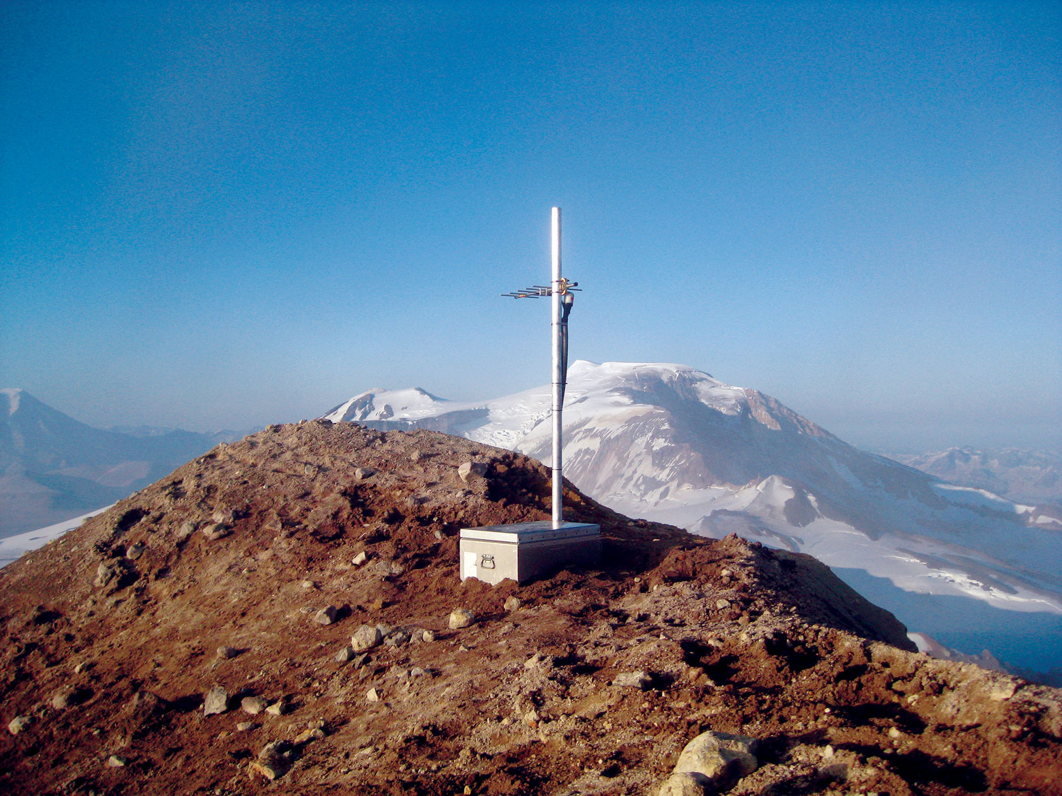
Figure 3. Mount Martin co-located seismic and MultiGas station with Mount Mageik in the background. Photo credit T. Lopez
July 14-18, 2013 – The weather conditions over the next several days deteriorated, with high clouds covering most of the summits, and a dense cloud build-up behind Katmai Pass – the gate to our last field target, Trident Volcano’s southeast fumarole field. Bo, Francesco and I spent much of this time at camp, downloading data from the NOVAC stations, and allowing Max and Dane to work on AVO seismic network maintenance. Luckily we had a few nice windows of opportunity during this time period and were able to install the MultiGas sensor and collect fumarole samples at Trident Volcano before having to say goodbye to Bo, Max, Dane, and Sam on July 18. Francesco and I had four more days to hike around the VTTS and collect water samples.
At the end of the July field campaign we had completed 7/8 of our proposed instrument installations and collected gas samples at 2/3 of the proposed volcanic fumarole fields. This was the most ambitious volcanic gas geochemistry effort to take place in Alaska since the 1990’s and we felt very happy with our accomplishments! Our plan was to leave the campaign instruments running over the next two months of summer and then to retrieve the instruments and data before fall arrived in September.
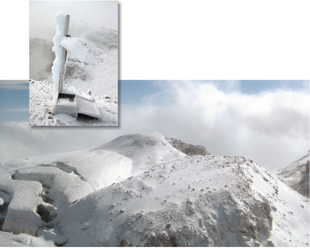
Figure 4. Summit of Mount Mageik as seen flying in on 4 September 2013. Figure 5. (left) The Mount Mageik MultiGas station as found on 4 September 2013. Photos credit T. Lopez
Part II:
Two days stranded on Mount Mageik
September 4, 2013 – I was back in King Salmon with my AVO colleague, John Paskievitch, who had offered to help me retrieve the instruments that my team had installed earlier that summer and who would also conduct some additional AVO maintenance on the Katmai seismic network. It was our first of three scheduled helicopter days to conduct this work and, unfortunately, the weather forecast for this field campaign was not encouraging. After running a few errands around town, John and I headed to Egli Air Haul to meet Sam and to weigh and organize our field gear. By early afternoon, the fog had thinned and we decided to fly to the VTTS to see if any fieldwork would be possible. To our surprise, the valley was clear and Mount Mageik’s summit was open (Fig. 4). After a quick stop at the Baked Mountain Huts to drop off any unnecessary weight and to get into our warmest clothes, we flew to Mount Mageik’s summit, arriving at ~3 PM.
Our station was located on a small hill between Mount Mageik’s four summits, on the rim of the actively degassing crater and surrounded on three sides by heavily crevassed glaciers. Upon our arrival to the station, John and I found that the station enclosure had become unlatched, was open, and the instruments and the station antenna mast were completely covered in thick rime ice (Fig. 5). We had blue skies above us but a dense wall of clouds was building up on the south side of Mount Mageik, and we knew that we had to watch the weather closely, as conditions could change very quickly. Sam stayed in the helicopter and watched the weather while John and I began to extract the instruments from the frozen ground. Approximately 30 minutes later Sam told us that the weather had deteriorated and we needed to leave NOW!
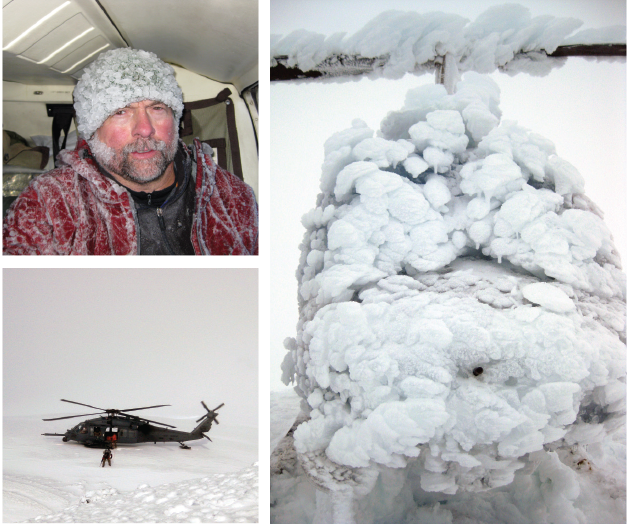
Clockwise from top left: Figure 6. (a) John Paskievitch as seen on 4 September 2013 after securing the helicopter with snow anchors in preparation for spending the night. (b) Helicopter covered in thick rime ice after ~16 hours on the summit of Mount Mageik (5 September 2013). (c) Alaska Air National Guard Rescue team and Pavehawk helicopter on Mount Mageik. Photos credit T. Lopez
John and I grabbed our equipment and helmets and were back in the helicopter in less than four minutes. Unfortunately, in those few minutes the clouds had rolled in, bringing with them freezing rain. Sam powered up the helicopter and we sat ready to take off at the first sign of improved visibility, while the helicopter blades were gradually accumulating ice. Approximately 15 minutes later, having had no improvement in visibility, Sam realized that the rotor blades had too much ice to fly. Sam powered down the helicopter and John and I made several futile attempts to scrape ice off the rotor blades. Conditions continued to deteriorate, and we realized that we would have to spend the night on the mountain and we would likely require rescue as our helicopter would probably not be flyable due to ice accumulation. We called Egli Air Haul and the AVO duty scientists to inform them of our situation and to ask them to notify the Alaska State Troopers.
In any survival training course you will learn that the first thing you should do in an emergency situation is to secure shelter. We were lucky to have brought our shelter with us, but with the high winds our helicopter was at risk of being blown down into the crater. Therefore, with Sam and I sitting in the helicopter to keep it weighed down, John spent several hours securing the helicopter with “dead-men” snow-anchors (Fig. 6a). By 9 PM our shelter was secure. Our next priority was simply to stay warm and dry, conserve energy, and wait for rescue. Thankfully we were well prepared for an emergency situation and had sufficient clothing, sleeping bags, sleeping pads, bivy-sacks, food, water, and communication supplies to keep us comfortable, at least in the short term. We also had a combination of ~55 years of experience doing field work in Alaska and I was very grateful for my highly experienced and resourceful comrades!
September 5, 2013 – After a fitful night of sleep with strong winds peaking at 75 mph, we woke to similarly dismal conditions, with continued freezing rain and poor visibility. We also found that the entire helicopter was covered in ~8 inches of rime ice, making it difficult to open the doors and even causing the helicopter’s frame to distort under the excess pressure (Fig. 6b). We passed the day quietly, dozing a lot, talking some, going outside as infrequently as possible, and looking forward to our regular satellite phone check-in calls with Egli Air Haul. By 5:00 PM that day, there was no improvement to the weather and no external rescue efforts had been planned. We realized that our situation could easily go from uncomfortable to life threatening if we were not rescued soon, especially considering that our shelter was at risk of being compromised with the increasing ice-load. At that point Sam turned on the helicopter’s Emergency Locator Transmission. Within an hour we received word that the Alaska Air National Guard (AANG) was mobilizing rescue teams. At 9:00 PM that evening we first heard the comforting sounds of our rescue aircraft nearby. The AANG had deployed two rescue teams to assist us. One team based on a C-130 airplane was flying over our position, looking for any potential breaks in weather, while the second aircraft, a Pavehawk helicopter, contained our ground-support team. Using our helicopter’s radio we were able to directly speak with the AANG pilots and set up regular check-in times to communicate with them in case of potential weather breaks. Unfortunately, a thick layer of clouds continued to keep us trapped through the night. We spent a second night in the helicopter, colder and less comfortable than the first, but encouraged by the regular sound of our rescue aircraft nearby.
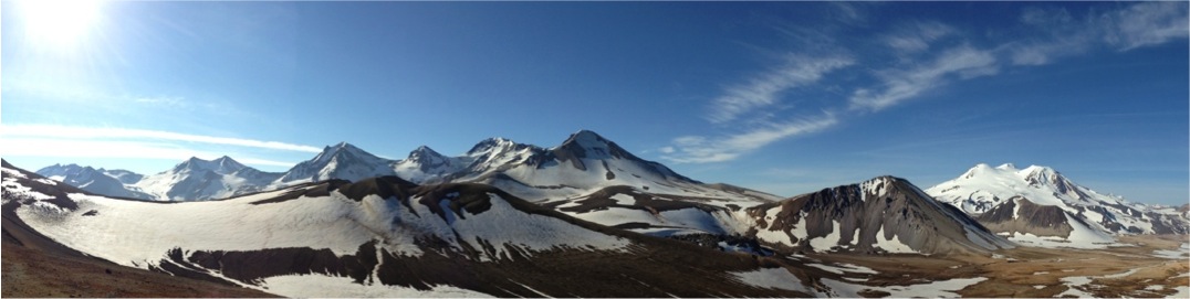
Panoramic view from the North of the Katmai Volcanic Cluster. Photo credit T. Lopez
September 6, 2013 – By 8:00 AM the next morning, the winds had dropped significantly and the temperature was rising. Most encouraging of all was that visibility had increased to ~20 m and the sky was brighter indicating a thinner cloud deck. By noon, the ice on the helicopter frame had begun to melt. Over the next three hours the Pavehawk helicopter flew back and forth over our location hoping to catch a break in the clouds and sweep in to rescue us. Using our hand-held USGS radios and the sound of their rotors, we helped them narrow in on our position. The clouds continued to thin and we were finally rewarded with the welcome sight of their massive helicopter! Minutes later, the Pavehawk had landed on the glacier below us and two of our rescuers, tethered to the Pavehawk, quickly crossed the glacier to meet us and escorted us back to safety (Fig. 6c)!
Our experience on Mount Mageik went about as well as it could have thanks to Sam’s resolve to not fly in unsafe conditions, John’s resourcefulness in anchoring the helicopter, our preparation with survival gear and training, an excellent support/communication team at home, and the competency and bravery of the AANG rescue team. I feel very lucky that all of these things came together so that I have the opportunity to share my story today. While I learned many important life lessons during this experience, I would like to share two of them here: (1) Spend as much time as possible with your loved ones as you never know what day will be your last, and (2) Fieldwork in Alaska should never be taken lightly, so ALWAYS carry your survival gear and have proper training! ■
“Report from the Field” was designed to inform the community of real-time, exciting GeoPRISMS -related research. Through this report, the authors expose the excitement, trials, and opportunities to conduct fieldwork, as well as the challenges they may have experienced by deploying research activities in unique geological settings. If you would like to contribute to this series and share your experience on the field, please contact the GeoPRISMS Office at info@geoprisms.nineplanetsllc.com. This opportunity is open to anyone engaged in GeoPRISMS research, from senior researchers to undergraduate students.
We hope to hear from you!