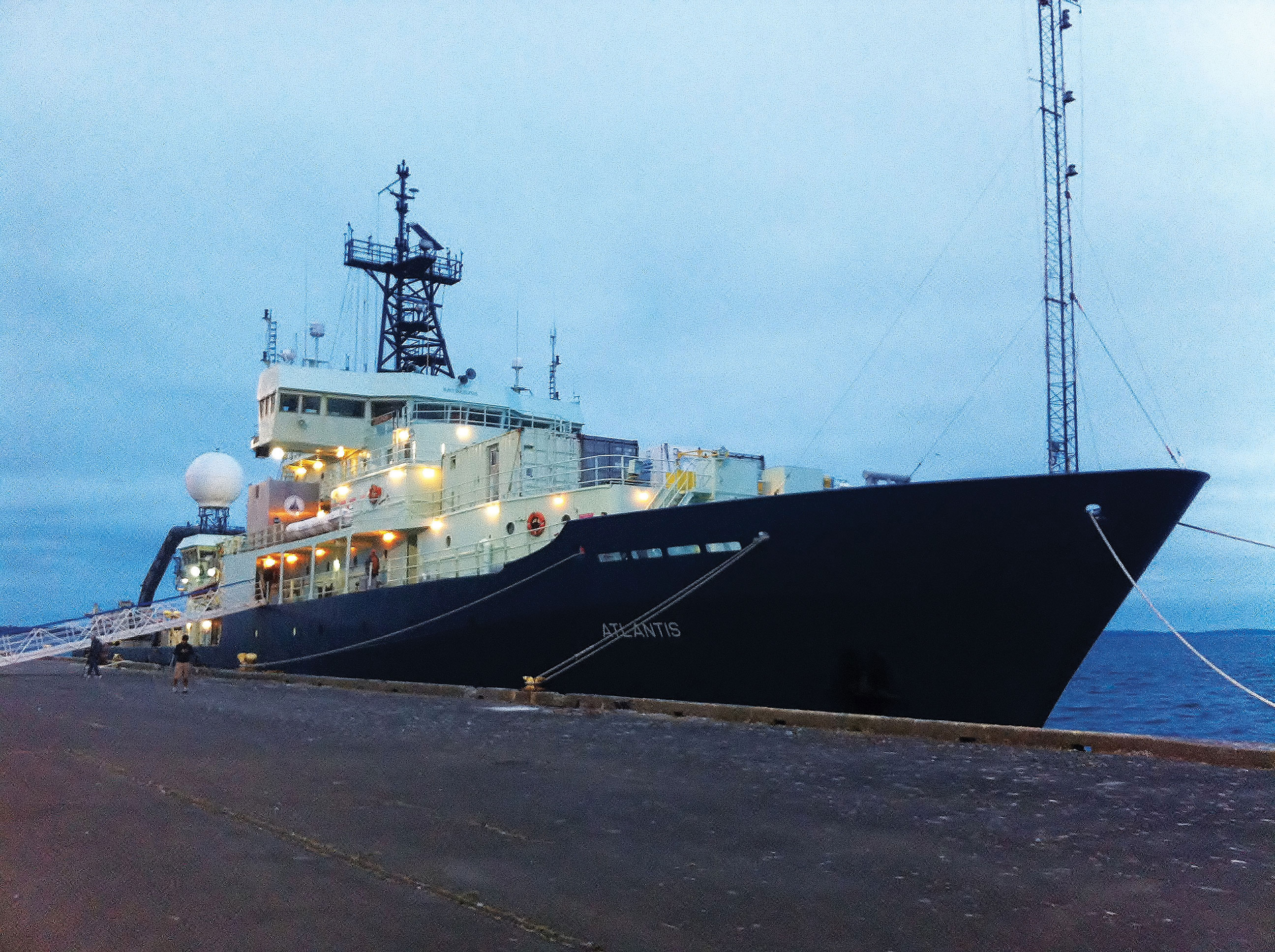
The R/V Atlantis
Our 204 heat flow and 23 fluid flux stations survey along a single cross-margin profile is the highest resolution series of such measurements ever made on a subduction zone accretionary wedge. Combined with previous R/V LANGSETH multi-channel seismic data previously acquired along the same profile, these measurements reveal a wealth of detail of active fluid pathways, tectonic complexity, and diverse thermal environments for the previously unstudied accretionary prism off the Washington coast. Processing of these rich data sets is just beginning but preliminary analysis of the results reveals several unexpected findings. These include the inflow of seawater into at least the uppermost sediment layers above the deformation front and first anticlinal ridge, higher temperatures (~225°C) of the sediment-basement interface at the deformation front than previously recognized and methane-rich fluid flux with a geochemical signature indicating that these fluids originate from a deep source at temperatures greater than 80°C within the accretionary prism. The Cascadia Subduction Zone (CSZ) that dives beneath the North American continent is relatively quiescent but poses a great seismic hazard to the NE Pacific coast. Although the northern and southern portions of the CSZ off-shore the Vancouver Island and Oregon coasts have been studied over the past 50 years, detailed geophysical studies of the section off the Washington State margin have been limited until recently due to its proximity to sensitive U.S. Navy access routes. With the lifting of the ban on high resolution multi-beam bathymetry maps of the area and the recognition that the CSZ is a quiet but active fault zone, the 250 km length of the Washington portion has received new attention, which included its election as a focus site for the National Science Foundation GeoPRISMS Program, a target area for the Cascadia Initiative Expedition Team Ocean Bottom Seismic array, and the focus of two multi-channel seismic surveys using the R/V LANGSETH in 2012. In August, 2013, we conducted a 30-day detailed heat flow and fluid flux survey along a single across-strike profile of the Washington margin from the abyssal plain west of the deformation front of the accretionary wedge at 3000 meters depth to the continental shelf at 160 meters water depth using the R/V ATLANTIS and the ROV JASON II. The scientific goals of this cruise were to:
- Determine the temperatures along the décollement of the CSZ megathrust fault, since temperature is an important influence on the locked portion of the fault.
- Identify and quantify both shallow and deep-seated fluid flow within the accretionary sediment wedge that overlies the megathrust fault zone.
- Test the hypothesis that active hydrothermal circulation within the subducting oceanic crust is occurring and if so, whether this oceanic plate aquifer is mining heat from deep within the subduction zone and serving as a ‘cold-finger’ for thermal processes beneath North American margin.
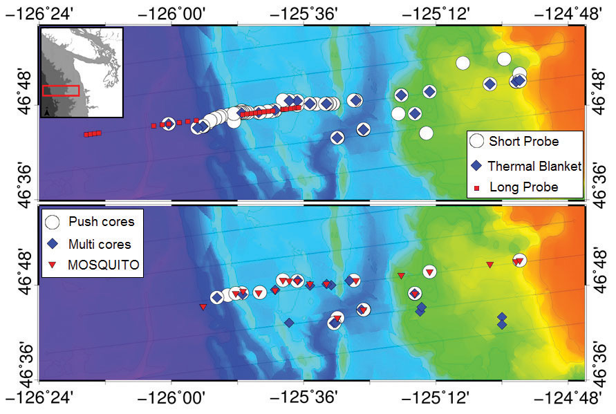
Figure 1. Top Image shows heat flow instrument sites from August 2013 GeoPRISMS cruise, including Jason short-probe, thermal blanket deployments, and OSU long-probe sites. Light grey lines are LANGSETH MCS 2012 survey lines. Insert shows general location of survey area. Lower map shows fluid flow sampling sites, including Mosquito flow meters, Jason push cores and multi-corer sediment coring sites.
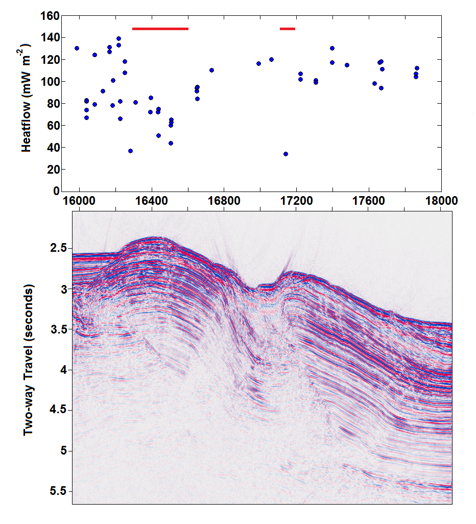
Figure 2. Top panel shows JASON short-probe heat flow data over the Deformation Front and First Anticlinal Ridge shown in Figure 1. Red bars show locations of reduced heat flow areas hypothesized to be areas of fluid inflow into the upper sediment layers. Lower LANGSETH seismic profile is co-registered with the heat flow stations and shows the Juan de Fuca plate entering the CSZ from the right and the deformation front and First Anticlinal Ridge. The x-axis is MCS Common Depth Point where 400 CDPs represents 2700 meters.
Although designed as a stand-alone research experiment, our field program is integrated with other recent and continuing GeoPRISMS and Department of Energy Hydrate Programs on Cascadia Subduction Zone. This integration is both a benefit and a necessity given the complex interdisciplinary scientific processes that are presented on the Washington margin. For example, we took advantage of the LANGSETH 2012 Multi-Channel Seismic (MCS) lines to identify sub-surface structures in our survey area and conducted heat flow and fluid flux measurement profiles over Line 4 from that cruise. Our data will also be eventually linked to the Cascadia Initiative Expedition Team (2011-2014) Ocean Bottom Seismometer data to help understand CSZ seismic behavior and hazards and to the planned Department of Energy cruise on the R/V THOMPSON (Solomon and Johnson) that focuses on understanding the response of upper slope gas hydrates to the observed warming of intermediate depth water temperatures off the Washington margin. In order to construct a single high-resolution profile of heat flow and fluid flux measurement across the Washington accretionary prism and adjacent abyssal plane we employed the entire suite of geophysical and hydrological tools available in order to approach the above scientific problems with a comprehensive program. Using the ROV JASON II, we deployed short heat flow probes (204 measurements), 28 thermal blankets, 23 Mosquito flow meters, and took 20 push cores to sample near-surface sediments for pore water chemistry. From the ATLANTIS surface ship we conducted EM122 detailed bathymetry and acoustic backscatter images from the abyssal plain to the shallow continental shelf, 9 CTD casts, 15 multi-core sediment recoveries, and 36 Oregon State University long-probe heat flow insertions.
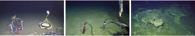
Figure 3. (left) JASON photo of Mosquito flow meter (left) and thermal blanket (right). (middle) Deployment of dual JASON short probe heat flow instruments, used for redundant measurements at a single heat flow site. (right) Frame grab of JASON video image of actively-forming authigenic carbonate deposit at a methane bubble emission site at 1000 meters water depth. Vertical dimension of photo is about 3 meters.
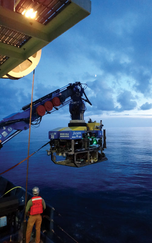
Remotely Operated Vehicle Jason II deployment operations during the R/V Atlantis cruise off the Washington Coast. Photo Credit Una Miller, UW/Oceanography student.
While these data sets are still being analyzed some results reveal the potential for preliminary interpretation. At the Juan de Fuca oceanic plate approach to the Washington CSZ heat flow data from all three applied methods (JASON short-probe, thermal blankets, OSU long-probe) yield a consistently high heat flow average value of near 100 mW/m2. When this value is downward continued through the incoming sediment column using in situ near-surface thermal conductivities combined with deeper values derived from LANGSETH seismic velocities it yields a basement-sediment interface temperature just west of the deformation front of 225°C. This newly estimated temperature substantially exceeds the canonical values of 100-150°C for fluid production from the smectite-illite transition previously used to define the up-slope boundary of the locked portion of megathrust faults. As our survey moves eastward across the deformation front and up-slope over the ‘second anticlinal ridge’, the closely-spaced heat flow measurements illuminate high spatial variability. This is caused by fluid flow that previously could not be resolved with widely-spaced surface ship measurements. These data show two narrow zones of dramatically decreased heat flow values over the summits of the two westernmost structures that can be interpreted as the inflow of seawater into the dilated uppermost sediment layers. Seismic profiles from the LANGSETH 2012 MCS survey also show structures resembling keystone graben faults at the summits of these western anticlinal ridges, which is consistent with a dilating upper sediment section. Ongoing processing of data from our Mosquito flow meters, sediment cores, and additional heat flow stations will further test this hypothesis. The Washington margin has been recognized for over 50 years as a methane-rich accretionary prism and recent studies have strongly reinforced this view. Our initial EM122 profiles of the survey area at the beginning of the cruise prior to launching our first JASON dives located several active methane emission sites with active bubble plumes rising hundreds of meters into the water column. During the course of the deployment of heat flow and fluid flux stations along the profile we encountered extensive areas of calcium carbonate pavements at the seafloor which in some areas resisted penetration of our heat flow probes and sediment coring instruments. At a thousand meters water depth we discovered several areas of active methane gas emissions and actively forming authigenic carbonate deposits, with delicate aragonite precipitation structures currently forming on the edges of massive carbonate slabs that were several meters thick and hundreds of meters in horizontal dimension. The basic heat flow and fluid flux work are the central data sets for two University of Washington PhD theses (M. Salmi and R. Berg). Processing of the abundance of diverse data collected over our 30-day field program is in progress and will be a fertile data set upon which to base future studies of the Cascadia Subduction Zone. An extension of the original NSF proposed work is a high resolution video survey as an experiment-of-opportunity of three of these methane emission sites and carbonate formation zones with the JASON video camera during the 2013 cruise. These video data and returned carbonate samples are now the core of a previously unplanned UW undergraduate (U. Miller) research project. ■
 Funding was through the NSF GeoPRISMS Program with grateful acknowledgement to the crews of R/V ATLANTIS and ROV JASON II. Scientific Party Team listed alphabetically consisted of Rick Berg, Tor Bjorklund, Rick Carlson, Dan Culling, Rob Harris, Casey Hearn, Kira Homola, Paul Johnson, Peter Kalk, Alex Mesher, Una Miller, Brendon Pratt, Adrian Rembold, Marie Salmi, Evan Solomon, and Jon Yang. The cruise investigators subscribe to the NSF Open Access policy and after initial processing the full suite of data will be available online.