The GeoPRISMS data portal was established in 2011 to provide convenient access to data and information for each primary site as well as to other data resources. Since the last newsletter report, highlighted below are recent contributions of data sets and field program information of interest to the GeoPRISMS community.
Aleutian Arc
The EarthChem-PetDB database, now in release version 2.8.1, is part of the NSF-funded IEDA data facility and provides a global synthesis of chemical, isotopic, and mineralogical data for rocks, minerals, and melt inclusions. Guidance from a group of Aleutian arc investigators has helped identify high-profile geochemical analytical data sets for the Aleutian Primary Site to aid the GeoPRISMS community with data synthesis and interpretation. Geochemical data sets and sample information from more than twenty articles published between 1971 and 2010 have so far been added to the database by the EarthChem team (Fig. 1) and can be accessed via PetDB (Search by “Feature Name >Volcanic Arc > Aleutian”) or via the EarthChem Portal (use the map-based ‘Set Location’ to define a polygon around your area of interest).
A second upload of Aleutian arc data will follow in early 2015, bringing the compilation of geochemical and mineralogical data sets to a total of nearly sixty publications. If you have suggestions for additional data sets or comments about the current data please contact the PetDB team at info <at> petdb.org.
Cascadia
High-resolution processed multibeam bathymetry grid surveys covering part of the continental shelf and slope offshore Washington state were contributed by GeoPRISMS investigator Paul Johnson. The swath data sets were collected during the seafloor mapping phases of cruises TN177 (2005) and TN207 (2007) cruises. Information on Cascadia Initiative Year 4 ocean bottom seismometer operations is also available. In addition, following a successful permitting process and an intensive installation program during the summer of 2014, station information for the Imaging Magma Under St. Helens (iMUSH) program has been added to the GeoPRISMS data portal and is accessible in GeoMapApp from the Focus Site menu (Fig. 2).
ENAM
Multichannel seismic field data files, in SEG-Y format, were added for the 1974 International Phase of Ocean Drilling (IPOD) Site Survey line from Cape Hatteras to the Mid-Atlantic Ridge. The data set was collected on cruise GS1974 that was led by John Grow and Rudi Markl. Also for the ENAM region, a Calais et al. (2006) geodetic vertical velocity data set for North America was added to GeoMapApp in both gridded and tabular format. Details of the recently-completed ENAM Community Seismic Experiment aboard R/V Langseth will soon be added to the data portal.
-
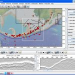
- Figure 1A. Recently added to the EarthChem-PetDB database are geochemical data sets along the length of the Aleutian arc. (Left) GeoMapApp screenshot showing the geographical extent of the newly-available geochemistry data (red dots). Black rectangles outline areas of multi-channel seismic reflection data, with the white rectangle showing the bounds of MCS profile lines from the 1994 cruise EW9409 led by Susan McGeary and John Diebold. Yellow lines are the locations of MCS profile EW9409-1232 (west) and EW9409-1237ryu (east) shown in the lower panel.
-
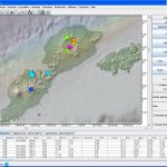
- Figure 1B. On the Aleutian island of Unmak, Okmok caldera dominates the island’s northeastern landscape and is one of the most active volcanoes in the Aleutian chain. Here, a second GeoMapApp screenshot shows Nd143/Nd144 ratios that were recently added to the PetDB database and are color-coded with warmer colors indicating higher values. Faint black lines trending NE-SW represent depth contours to the top of the subducting slab from Syracuse and Abers (2006). Contours are at 10 km intervals with the 60 km contour passing through Okmok caldera. Land elevations, in shades of green, are from the USGS-NED and ASTER elevations models.
-
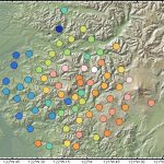
- Figure 2. Seismometer station locations for the two-year passive array deployment of the Cascadia iMUSH multi-institution program (lead PI Ken Creager). Stations are plotted in GeoMapApp on a 10-meter GMRT base map and shaded according to station elevation, with warmer colors indicating higher elevations. The array comprises 71 stations centered upon Mount St. Helens and links in GeoMapApp point to detailed station and network information at IRIS.
GeoPRISMS Data Portal Tools and Resources
Search For Data – The customised GeoPRISMS search tool provides a quick way to find GeoPRISMS data using parameters such as keyword, NSF award number, publications, and geographical extent.
Data Management Plan tool – Generate a data management plan for your NSF proposal. The on-line form can be quickly filled in, printed in PDF format, and attached to a proposal. PIs can use an old plan as a template to create a new plan. We also have developed a tool to help PIs show compliance with NSF data policies.
GeoPRISMS Bibliography – With more than 730 citations, many tied to data sets, the references can be searched by primary site, paper title, author, year, and journal. The lists of publications can be exported to EndNote™. Submit your papers – just the DOI is needed – for inclusion in the bibliography!
GeoMapApp – Free map-based data exploration and visualization tool, updated with the release of version 3.4.1 in October 2014. Enhancements include an improved interface for plotting large tabular data sets – GMRT base map tiles that now load sequentially – a beta Save Sessions/Import Sessions function that provides limited ability to save, store and re-use an instance of a GeoMapApp session, a better capability to import multiple grids at once, and a range of other modifications and bug fixes requested by the community.
Version 2.6 of the GMRT base map includes newly-added swath bathymetry for the Cascadia, Alaska-Aleutians, and ENAM primary sites. A GeoPRISMS-focused webinar is available on the GeoMapApp channel and shows how to generate custom maps, how to explore built-in data sets of interest to the GeoPRISMS community, and how to import your own data.
Contribute Data – This updated web tool provides a simple way to submit grid files, tabular data sets, spreadsheets, and shapefiles. Once added to the GeoPRISMS database, these data sets become immediately available to the broader community or can be placed on restricted hold.
References
Calais, E., Han, J.Y., DeMets, C., Nocquet, J.M. (2006). Deformation of the North American plate interior from a decade of continuous GPS measurements. J. Geophys. Res. 111(B6), DOI: 10.1029/2005JB004253.
Syracuse, E.M., Abers, G. A. (2006). Global compilation of variations in slab depth beneath arc volcanoes and implications. Geochem. Geophy. Geosy., 7(5), DOI: 10.1029/2005GC001045.