The GeoPRISMS data portal was established in 2011 to provide convenient access to data and information for each primary site as well as to other data resources. Since the last newsletter report, highlighted below are recent contributions of data sets and field program information of interest to the GeoPRISMS community. Most of the data sets described are also available in GeoMapApp under the Focus Site menu.
Aleutian Arc
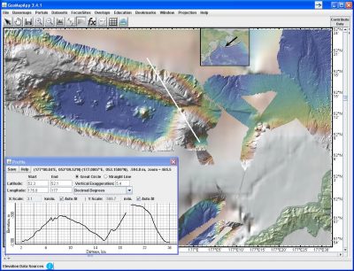
Bathymetric grids, generated at 50m horizontal resolution from processed EM300 multibeam swath data, were contributed by Gene Yogodzinski and Scott White from data acquired in 2005 during a geophysical and geochemical survey of the Aleutian back-arc (Fig. 1). In the last newsletter, we reported on Aleutian arc geochemistry and mineralogical data from twenty published articles being included in the EarthChem-PetDB database. A new batch of analytical data from a further 31 papers published between 1971 and 2010 has since been included. The data sets from this new compilation can be accessed via PetDB (Search by “Feature Name > Volcanic Arc > Aleutian”) or via the EarthChem Portal (use the map-based “Set Location” to define a polygon around your area of interest). If you have suggestions for additional data sets or comments about the current data please contact the PetDB team at info@petdb.org.
EARS
A preliminary East African Rift System geodetic velocity field compiled from continuous and survey mode GPS networks was contributed by Bob King, Michael Floyd, Rob Reilinger, and Becky Bendick. Derived from field data acquired between 1994 and 2013, the data set is part of a wider Africa-Arabia-Eurasia velocity field calculation and is available here.
Cascadia
Details on Cascadia Initiative Year 4 ocean bottom seismometer deployment and recovery operations are available, along with MT instrument locations for the on-going land-based iMUSH program. Station information for Dave Chadwell’s seafloor geodesy transponder array was also added. From their 2013 cruise AT26-04, Paul Johnson, Evan Solomon, and Rob Harris provided long probe and thermal blanket processed heat flow data. For the Juan de Fuca Endeavour segment, PIs William Wilcock, Emilie Hooft Toomey, and Doug Toomey contributed an earthquake microseismicity catalog for years 2003-2006 as well as a seismic velocity model for the area.
ENAM
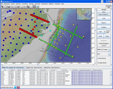
The main offshore component of the multi-PI, shoreline-crossing ENAM Community Seismic Experiment took place in Fall 2014 with an R/V Langseth seismic survey. Shots were recorded by Langseth streamers and ocean floor OBS instruments as well as by broadband and short-period seismometers on land. Multi-channel seismic data and field information from the experiment, including land seismometer and OBS deployments, were added to the portal (Fig. 2). Information and data for the preceding Langseth cruise – a USGS Extended Continental Shelf survey, led by Deb Hutchinson and Nate Miller – were also contributed.


GeoPRISMS Data Portal Tools and Resources
Search For Data – The customised GeoPRISMS search tool provides a quick way to find GeoPRISMS data using parameters such as keyword, NSF award number, publications, and geographical extent.
Data Management Plan tool – generates a data management plan for your NSF proposal. The on-line form can be quickly filled in, printed in PDF format, and attached to a proposal. PIs can use an old plan as a template to create a new plan. We also have developed a tool to help PIs show compliance with NSF data policies.
GeoPRISMS Bibliography – with more than 760 citations, many tied to data sets. The references can be searched by primary site, paper title, author, year, and journal. The lists of publications can be exported to EndNote™. Submit your papers for inclusion in the bibliography – just the DOI is needed!
GeoMapApp /GMRT – version 2.7 of the GMRT base map includes newly-added swath bathymetry data from eight cruises in the Cascadia region.
Contribute Data – This updated web submission tools support PI contributions of geophysical, geochemical, and sample data. File formats include grids, tables, spreadsheets, and shapefiles. Once registered within the IEDA system, the data sets become available to the broader community immediately or may be placed on restricted hold. Additionally, PIs can choose to have a DOI assigned to each submitted data set, allowing it to become part of the formal, citable scientific record. ■
